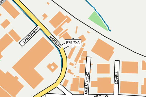
B79 7XA lies on Neander in Tamworth. B79 7XA is located in the Mercian electoral ward, within the local authority district of Tamworth and the English Parliamentary constituency of Tamworth. The Sub Integrated Care Board (ICB) Location is NHS Staffordshire and Stoke-on-Trent ICB - 05Q and the police force is Staffordshire. This postcode has been in use since April 1987.


GetTheData
Source: OS OpenMap – Local (Ordnance Survey)
Source: OS VectorMap District (Ordnance Survey)
Licence: Open Government Licence (requires attribution)
| Easting | 419725 |
| Northing | 304739 |
| Latitude | 52.640058 |
| Longitude | -1.709936 |
GetTheData
Source: Open Postcode Geo
Licence: Open Government Licence
| Street | Neander |
| Town/City | Tamworth |
| Country | England |
| Postcode District | B79 |
➜ See where B79 is on a map ➜ Where is Tamworth? | |
GetTheData
Source: Land Registry Price Paid Data
Licence: Open Government Licence
Elevation or altitude of B79 7XA as distance above sea level:
| Metres | Feet | |
|---|---|---|
| Elevation | 60m | 197ft |
Elevation is measured from the approximate centre of the postcode, to the nearest point on an OS contour line from OS Terrain 50, which has contour spacing of ten vertical metres.
➜ How high above sea level am I? Find the elevation of your current position using your device's GPS.
GetTheData
Source: Open Postcode Elevation
Licence: Open Government Licence
| Ward | Mercian |
| Constituency | Tamworth |
GetTheData
Source: ONS Postcode Database
Licence: Open Government Licence
| Chambers Of Tamworth (Lichfield Road) | The Leys | 464m |
| Downing Drive (Lichfield Rd) | Lichfield Road Industrial Estate | 496m |
| Gagarin (Lichfield Road) | The Leys | 501m |
| Buckingham Road (Lichfield Rd) | Lichfield Road Industrial Estate | 515m |
| Shopping Precinct (Fontenaye Rd) | Coton Green | 532m |
| Tamworth Station | 1.6km |
| Tamworth High Level Station | 1.6km |
| Wilnecote (Staffs) Station | 3.9km |
GetTheData
Source: NaPTAN
Licence: Open Government Licence
GetTheData
Source: ONS Postcode Database
Licence: Open Government Licence


➜ Get more ratings from the Food Standards Agency
GetTheData
Source: Food Standards Agency
Licence: FSA terms & conditions
| Last Collection | |||
|---|---|---|---|
| Location | Mon-Fri | Sat | Distance |
| Mariner | 18:30 | 11:30 | 170m |
| Coton Green Post Office | 17:15 | 11:30 | 597m |
| Lincoln Avenue / Lichfield Roa | 17:15 | 11:30 | 674m |
GetTheData
Source: Dracos
Licence: Creative Commons Attribution-ShareAlike
| Risk of B79 7XA flooding from rivers and sea | Low |
| ➜ B79 7XA flood map | |
GetTheData
Source: Open Flood Risk by Postcode
Licence: Open Government Licence
The below table lists the International Territorial Level (ITL) codes (formerly Nomenclature of Territorial Units for Statistics (NUTS) codes) and Local Administrative Units (LAU) codes for B79 7XA:
| ITL 1 Code | Name |
|---|---|
| TLG | West Midlands (England) |
| ITL 2 Code | Name |
| TLG2 | Shropshire and Staffordshire |
| ITL 3 Code | Name |
| TLG24 | Staffordshire CC |
| LAU 1 Code | Name |
| E07000199 | Tamworth |
GetTheData
Source: ONS Postcode Directory
Licence: Open Government Licence
The below table lists the Census Output Area (OA), Lower Layer Super Output Area (LSOA), and Middle Layer Super Output Area (MSOA) for B79 7XA:
| Code | Name | |
|---|---|---|
| OA | E00152106 | |
| LSOA | E01029850 | Tamworth 002D |
| MSOA | E02006218 | Tamworth 002 |
GetTheData
Source: ONS Postcode Directory
Licence: Open Government Licence
| B79 7TA | Anders Road | 187m |
| B79 8NE | Edgar Close | 375m |
| B79 8DA | Arnold Close | 393m |
| B79 8LB | Athelstan Way | 422m |
| B79 8DE | Elizabeth Drive | 433m |
| B79 8LA | Guys Close | 445m |
| B79 7SG | Swallowfield | 446m |
| B79 8DB | Kingsley Close | 466m |
| B79 7UP | Wynyates | 478m |
| B79 8DF | Elizabeth Drive | 478m |
GetTheData
Source: Open Postcode Geo; Land Registry Price Paid Data
Licence: Open Government Licence