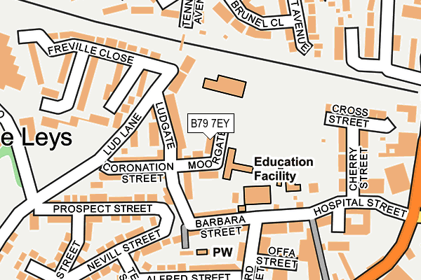
B79 7EY lies on Moorgate in Tamworth. B79 7EY is located in the Spital electoral ward, within the local authority district of Tamworth and the English Parliamentary constituency of Tamworth. The Sub Integrated Care Board (ICB) Location is NHS Staffordshire and Stoke-on-Trent ICB - 05Q and the police force is Staffordshire. This postcode has been in use since December 2002.


GetTheData
Source: OS OpenMap – Local (Ordnance Survey)
Source: OS VectorMap District (Ordnance Survey)
Licence: Open Government Licence (requires attribution)
| Easting | 420463 |
| Northing | 304439 |
| Latitude | 52.637316 |
| Longitude | -1.699055 |
GetTheData
Source: Open Postcode Geo
Licence: Open Government Licence
| Street | Moorgate |
| Town/City | Tamworth |
| Country | England |
| Postcode District | B79 |
➜ See where B79 is on a map ➜ Where is Tamworth? | |
GetTheData
Source: Land Registry Price Paid Data
Licence: Open Government Licence
Elevation or altitude of B79 7EY as distance above sea level:
| Metres | Feet | |
|---|---|---|
| Elevation | 70m | 230ft |
Elevation is measured from the approximate centre of the postcode, to the nearest point on an OS contour line from OS Terrain 50, which has contour spacing of ten vertical metres.
➜ How high above sea level am I? Find the elevation of your current position using your device's GPS.
GetTheData
Source: Open Postcode Elevation
Licence: Open Government Licence
| Ward | Spital |
| Constituency | Tamworth |
GetTheData
Source: ONS Postcode Database
Licence: Open Government Licence
| Woodcroft Avenue (Salters Ln) | Leyfields | 254m |
| Aldergate Clinic (Salters Lane) | Leyfields | 286m |
| Tennyson Avenue (Masefield Dr) | Leyfields | 286m |
| Hospital Street (Upper Gungate) | Tamworth Town Centre | 293m |
| Aldergate Clinic (Salters Lane) | Leyfields | 296m |
| Tamworth Station | 0.9km |
| Tamworth High Level Station | 0.9km |
| Wilnecote (Staffs) Station | 3.2km |
GetTheData
Source: NaPTAN
Licence: Open Government Licence
| Percentage of properties with Next Generation Access | 100.0% |
| Percentage of properties with Superfast Broadband | 100.0% |
| Percentage of properties with Ultrafast Broadband | 0.0% |
| Percentage of properties with Full Fibre Broadband | 0.0% |
Superfast Broadband is between 30Mbps and 300Mbps
Ultrafast Broadband is > 300Mbps
| Percentage of properties unable to receive 2Mbps | 0.0% |
| Percentage of properties unable to receive 5Mbps | 0.0% |
| Percentage of properties unable to receive 10Mbps | 0.0% |
| Percentage of properties unable to receive 30Mbps | 0.0% |
GetTheData
Source: Ofcom
Licence: Ofcom Terms of Use (requires attribution)
Estimated total energy consumption in B79 7EY by fuel type, 2015.
| Consumption (kWh) | 29,916 |
|---|---|
| Meter count | 7 |
| Mean (kWh/meter) | 4,274 |
| Median (kWh/meter) | 4,579 |
GetTheData
Source: Postcode level gas estimates: 2015 (experimental)
Source: Postcode level electricity estimates: 2015 (experimental)
Licence: Open Government Licence
GetTheData
Source: ONS Postcode Database
Licence: Open Government Licence


➜ Get more ratings from the Food Standards Agency
GetTheData
Source: Food Standards Agency
Licence: FSA terms & conditions
| Last Collection | |||
|---|---|---|---|
| Location | Mon-Fri | Sat | Distance |
| 2 Albert Road | 18:30 | 11:30 | 364m |
| Balfour | 18:30 | 11:30 | 484m |
| Tamworth P.o. | 18:45 | 12:30 | 509m |
GetTheData
Source: Dracos
Licence: Creative Commons Attribution-ShareAlike
The below table lists the International Territorial Level (ITL) codes (formerly Nomenclature of Territorial Units for Statistics (NUTS) codes) and Local Administrative Units (LAU) codes for B79 7EY:
| ITL 1 Code | Name |
|---|---|
| TLG | West Midlands (England) |
| ITL 2 Code | Name |
| TLG2 | Shropshire and Staffordshire |
| ITL 3 Code | Name |
| TLG24 | Staffordshire CC |
| LAU 1 Code | Name |
| E07000199 | Tamworth |
GetTheData
Source: ONS Postcode Directory
Licence: Open Government Licence
The below table lists the Census Output Area (OA), Lower Layer Super Output Area (LSOA), and Middle Layer Super Output Area (MSOA) for B79 7EY:
| Code | Name | |
|---|---|---|
| OA | E00152125 | |
| LSOA | E01029851 | Tamworth 002E |
| MSOA | E02006218 | Tamworth 002 |
GetTheData
Source: ONS Postcode Directory
Licence: Open Government Licence
| B79 7EL | Moorgate | 49m |
| B79 7EQ | Ludgate | 54m |
| B79 7EG | Ludgate | 76m |
| B79 7EN | Ludgate | 103m |
| B79 7ES | Coronation Street | 119m |
| B79 7EJ | Barbara Street | 126m |
| B79 7EW | Lud Lane | 129m |
| B79 7EU | Prospect Street | 150m |
| B79 7EE | Hospital Street | 162m |
| B79 7RH | Orchard Street | 178m |
GetTheData
Source: Open Postcode Geo; Land Registry Price Paid Data
Licence: Open Government Licence