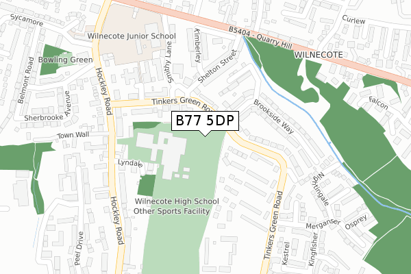
B77 5DP is located in the Wilnecote electoral ward, within the local authority district of Tamworth and the English Parliamentary constituency of Tamworth. The Sub Integrated Care Board (ICB) Location is NHS Staffordshire and Stoke-on-Trent ICB - 05Q and the police force is Staffordshire. This postcode has been in use since April 2020.


GetTheData
Source: OS Open Zoomstack (Ordnance Survey)
Licence: Open Government Licence (requires attribution)
Attribution: Contains OS data © Crown copyright and database right 2024
Source: Open Postcode Geo
Licence: Open Government Licence (requires attribution)
Attribution: Contains OS data © Crown copyright and database right 2024; Contains Royal Mail data © Royal Mail copyright and database right 2024; Source: Office for National Statistics licensed under the Open Government Licence v.3.0
| Easting | 423223 |
| Northing | 301050 |
| Latitude | 52.606757 |
| Longitude | -1.658500 |
GetTheData
Source: Open Postcode Geo
Licence: Open Government Licence
| Country | England |
| Postcode District | B77 |
➜ See where B77 is on a map ➜ Where is Tamworth? | |
GetTheData
Source: Land Registry Price Paid Data
Licence: Open Government Licence
| Ward | Wilnecote |
| Constituency | Tamworth |
GetTheData
Source: ONS Postcode Database
Licence: Open Government Licence
2024 28 MAR £375,000 |
2023 3 MAY £357,000 |
2021 8 DEC £356,000 |
5, ASH TREE CLOSE, WILNECOTE, TAMWORTH, B77 5DP 2021 28 SEP £360,000 |
3, ASH TREE CLOSE, WILNECOTE, TAMWORTH, B77 5DP 2021 26 JUL £360,000 |
4, ASH TREE CLOSE, WILNECOTE, TAMWORTH, B77 5DP 2021 23 JUL £450,000 |
2021 26 FEB £360,000 |
GetTheData
Source: HM Land Registry Price Paid Data
Licence: Contains HM Land Registry data © Crown copyright and database right 2024. This data is licensed under the Open Government Licence v3.0.
| Watling Street (Watling St) | Wilnecote | 245m |
| Watling Street | Wilnecote | 255m |
| Hastings Close (Tinkers Green Road) | Hockley | 285m |
| Bakers Walk (Tinkers Green Road) | Hockley | 303m |
| Hastings Close (Tinkers Green Rd) | Hockley | 314m |
| Wilnecote (Staffs) Station | 1.5km |
| Polesworth Station | 3.9km |
| Tamworth High Level Station | 3.9km |
GetTheData
Source: NaPTAN
Licence: Open Government Licence
GetTheData
Source: ONS Postcode Database
Licence: Open Government Licence


➜ Get more ratings from the Food Standards Agency
GetTheData
Source: Food Standards Agency
Licence: FSA terms & conditions
| Last Collection | |||
|---|---|---|---|
| Location | Mon-Fri | Sat | Distance |
| Granada Services | 17:30 | 11:00 | 1,190m |
| Malham Road / Lowforce | 18:00 | 11:30 | 1,347m |
| Belgrave Post Office | 18:00 | 11:30 | 1,589m |
GetTheData
Source: Dracos
Licence: Creative Commons Attribution-ShareAlike
The below table lists the International Territorial Level (ITL) codes (formerly Nomenclature of Territorial Units for Statistics (NUTS) codes) and Local Administrative Units (LAU) codes for B77 5DP:
| ITL 1 Code | Name |
|---|---|
| TLG | West Midlands (England) |
| ITL 2 Code | Name |
| TLG2 | Shropshire and Staffordshire |
| ITL 3 Code | Name |
| TLG24 | Staffordshire CC |
| LAU 1 Code | Name |
| E07000199 | Tamworth |
GetTheData
Source: ONS Postcode Directory
Licence: Open Government Licence
The below table lists the Census Output Area (OA), Lower Layer Super Output Area (LSOA), and Middle Layer Super Output Area (MSOA) for B77 5DP:
| Code | Name | |
|---|---|---|
| OA | E00152192 | |
| LSOA | E01029865 | Tamworth 008E |
| MSOA | E02006224 | Tamworth 008 |
GetTheData
Source: ONS Postcode Directory
Licence: Open Government Licence
| B77 5DA | Quarry Hill | 71m |
| B77 5PW | Sandstone Court | 79m |
| B77 5AN | Ravenswood Gardens | 107m |
| B77 5PJ | Stonydelph Lane | 128m |
| B77 5PL | Curlew | 136m |
| B77 5BW | Quarry Hill | 151m |
| B77 5DN | Falcon | 191m |
| B77 5BN | Quarry Hill | 199m |
| B77 5PQ | Brambling | 211m |
| B77 5BX | Quarry Hill | 218m |
GetTheData
Source: Open Postcode Geo; Land Registry Price Paid Data
Licence: Open Government Licence