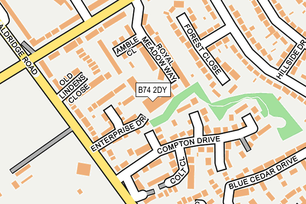
B74 2DY is located in the Streetly electoral ward, within the metropolitan district of Walsall and the English Parliamentary constituency of Aldridge-Brownhills. The Sub Integrated Care Board (ICB) Location is NHS Black Country ICB - D2P2L and the police force is West Midlands. This postcode has been in use since January 1991.


GetTheData
Source: OS OpenMap – Local (Ordnance Survey)
Source: OS VectorMap District (Ordnance Survey)
Licence: Open Government Licence (requires attribution)
| Easting | 407404 |
| Northing | 297207 |
| Latitude | 52.572635 |
| Longitude | -1.892185 |
GetTheData
Source: Open Postcode Geo
Licence: Open Government Licence
| Country | England |
| Postcode District | B74 |
➜ See where B74 is on a map ➜ Where is Streetly? | |
GetTheData
Source: Land Registry Price Paid Data
Licence: Open Government Licence
Elevation or altitude of B74 2DY as distance above sea level:
| Metres | Feet | |
|---|---|---|
| Elevation | 180m | 591ft |
Elevation is measured from the approximate centre of the postcode, to the nearest point on an OS contour line from OS Terrain 50, which has contour spacing of ten vertical metres.
➜ How high above sea level am I? Find the elevation of your current position using your device's GPS.
GetTheData
Source: Open Postcode Elevation
Licence: Open Government Licence
| Ward | Streetly |
| Constituency | Aldridge-brownhills |
GetTheData
Source: ONS Postcode Database
Licence: Open Government Licence
| Farmer Johns (Aldridge Rd) | Hundred Acre | 157m |
| Farmer Johns (Aldridge Rd) | Hundred Acre | 164m |
| Maxholm Rd (Bridle Lane) | Hundred Acre | 190m |
| Maxholm Rd (Bridle Lane) | Hundred Acre | 209m |
| Bridle Lane (Hundred Acre Rd) | Hundred Acre | 227m |
| Butlers Lane Station | 4.3km |
| Four Oaks Station | 4.4km |
| Sutton Coldfield Station | 4.6km |
GetTheData
Source: NaPTAN
Licence: Open Government Licence
GetTheData
Source: ONS Postcode Database
Licence: Open Government Licence


➜ Get more ratings from the Food Standards Agency
GetTheData
Source: Food Standards Agency
Licence: FSA terms & conditions
| Last Collection | |||
|---|---|---|---|
| Location | Mon-Fri | Sat | Distance |
| Streetly Works | 17:30 | 12:00 | 246m |
| Boundary Road / Hundred Acre Road | 17:30 | 12:00 | 452m |
| Bridle Lane Post Office | 17:15 | 12:00 | 733m |
GetTheData
Source: Dracos
Licence: Creative Commons Attribution-ShareAlike
The below table lists the International Territorial Level (ITL) codes (formerly Nomenclature of Territorial Units for Statistics (NUTS) codes) and Local Administrative Units (LAU) codes for B74 2DY:
| ITL 1 Code | Name |
|---|---|
| TLG | West Midlands (England) |
| ITL 2 Code | Name |
| TLG3 | West Midlands |
| ITL 3 Code | Name |
| TLG38 | Walsall |
| LAU 1 Code | Name |
| E08000030 | Walsall |
GetTheData
Source: ONS Postcode Directory
Licence: Open Government Licence
The below table lists the Census Output Area (OA), Lower Layer Super Output Area (LSOA), and Middle Layer Super Output Area (MSOA) for B74 2DY:
| Code | Name | |
|---|---|---|
| OA | E00052473 | |
| LSOA | E01010390 | Walsall 032C |
| MSOA | E02002141 | Walsall 032 |
GetTheData
Source: ONS Postcode Directory
Licence: Open Government Licence
| B74 2BL | Enterprise Drive | 66m |
| B74 2DJ | Matchlock Close | 68m |
| B74 2BE | The Range | 73m |
| B74 2DA | Compton Drive | 79m |
| B74 2DL | Gunstock Close | 81m |
| B74 2DZ | Enterprise Drive | 86m |
| B74 2FE | Royal Meadow Way | 102m |
| B74 2FP | Amble Close | 121m |
| B74 2DR | Aldridge Road | 132m |
| B74 2EA | Colt Close | 139m |
GetTheData
Source: Open Postcode Geo; Land Registry Price Paid Data
Licence: Open Government Licence