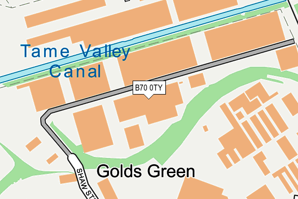
B70 0TY is located in the Wednesbury South electoral ward, within the metropolitan district of Sandwell and the English Parliamentary constituency of West Bromwich West. The Sub Integrated Care Board (ICB) Location is NHS Black Country ICB - D2P2L and the police force is West Midlands. This postcode has been in use since January 2017.


GetTheData
Source: OS OpenMap – Local (Ordnance Survey)
Source: OS VectorMap District (Ordnance Survey)
Licence: Open Government Licence (requires attribution)
| Easting | 398521 |
| Northing | 293439 |
| Latitude | 52.538823 |
| Longitude | -2.023232 |
GetTheData
Source: Open Postcode Geo
Licence: Open Government Licence
| Country | England |
| Postcode District | B70 |
➜ See where B70 is on a map ➜ Where is West Bromwich? | |
GetTheData
Source: Land Registry Price Paid Data
Licence: Open Government Licence
Elevation or altitude of B70 0TY as distance above sea level:
| Metres | Feet | |
|---|---|---|
| Elevation | 140m | 459ft |
Elevation is measured from the approximate centre of the postcode, to the nearest point on an OS contour line from OS Terrain 50, which has contour spacing of ten vertical metres.
➜ How high above sea level am I? Find the elevation of your current position using your device's GPS.
GetTheData
Source: Open Postcode Elevation
Licence: Open Government Licence
| Ward | Wednesbury South |
| Constituency | West Bromwich West |
GetTheData
Source: ONS Postcode Database
Licence: Open Government Licence
| Harvills Hawthorn | Harvils Hawthorne | 53m |
| Harvills Hawthorn | Harvils Hawthorne | 93m |
| The Miners Arms (Bagnall St) | Harvils Hawthorne | 143m |
| Ashmole Road (Anson Rd) | Harvils Hawthorne | 178m |
| Ashmole Road (Anson Rd) | Harvils Hawthorne | 201m |
| Wednesbury Great Western Street (Metro Stop) (Great Western St) | Wednesbury | 1,085m |
| Black Lake (Midland Metro Stop) (Black Lake) | Black Lake | 1,245m |
| Wednesbury Parkway (Midland Metro Stop) (Leabrook Rd) | Wednesbury | 1,289m |
| Dudley Port Station | 2.4km |
| Tipton Station | 3km |
| Sandwell & Dudley Station | 3.4km |
GetTheData
Source: NaPTAN
Licence: Open Government Licence
GetTheData
Source: ONS Postcode Database
Licence: Open Government Licence


➜ Get more ratings from the Food Standards Agency
GetTheData
Source: Food Standards Agency
Licence: FSA terms & conditions
| Last Collection | |||
|---|---|---|---|
| Location | Mon-Fri | Sat | Distance |
| Tame Street | 17:45 | 12:00 | 673m |
| Pemberton Road Facing Meyrick Road | 17:30 | 11:00 | 955m |
| Great Bridge St Opposite Charl | 17:30 | 12:00 | 1,119m |
GetTheData
Source: Dracos
Licence: Creative Commons Attribution-ShareAlike
The below table lists the International Territorial Level (ITL) codes (formerly Nomenclature of Territorial Units for Statistics (NUTS) codes) and Local Administrative Units (LAU) codes for B70 0TY:
| ITL 1 Code | Name |
|---|---|
| TLG | West Midlands (England) |
| ITL 2 Code | Name |
| TLG3 | West Midlands |
| ITL 3 Code | Name |
| TLG37 | Sandwell |
| LAU 1 Code | Name |
| E08000028 | Sandwell |
GetTheData
Source: ONS Postcode Directory
Licence: Open Government Licence
The below table lists the Census Output Area (OA), Lower Layer Super Output Area (LSOA), and Middle Layer Super Output Area (MSOA) for B70 0TY:
| Code | Name | |
|---|---|---|
| OA | E00051043 | |
| LSOA | E01010095 | Sandwell 013C |
| MSOA | E02002055 | Sandwell 013 |
GetTheData
Source: ONS Postcode Directory
Licence: Open Government Licence
| B70 0TP | Warwick Close | 107m |
| B70 0LZ | Anson Road | 208m |
| B70 0TX | Shaw Street | 251m |
| B70 0NE | Anson Road | 253m |
| B70 0TR | St Pauls Crescent | 256m |
| B70 0NA | Anson Road | 256m |
| B70 0LX | Anson Road | 258m |
| B70 0UF | Harvills Hawthorn | 279m |
| B70 0ND | Ashmole Road | 281m |
| B70 0TU | Pikehelve Street | 295m |
GetTheData
Source: Open Postcode Geo; Land Registry Price Paid Data
Licence: Open Government Licence