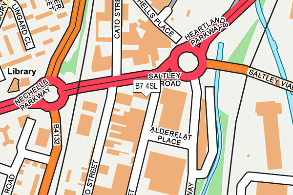
B7 4SL is located in the Nechells electoral ward, within the metropolitan district of Birmingham and the English Parliamentary constituency of Birmingham, Ladywood. The Sub Integrated Care Board (ICB) Location is NHS Birmingham and Solihull ICB - 15E and the police force is West Midlands. This postcode has been in use since January 1980.


GetTheData
Source: OS OpenMap – Local (Ordnance Survey)
Source: OS VectorMap District (Ordnance Survey)
Licence: Open Government Licence (requires attribution)
| Easting | 409032 |
| Northing | 288089 |
| Latitude | 52.490656 |
| Longitude | -1.868404 |
GetTheData
Source: Open Postcode Geo
Licence: Open Government Licence
| Country | England |
| Postcode District | B7 |
➜ See where B7 is on a map ➜ Where is Birmingham? | |
GetTheData
Source: Land Registry Price Paid Data
Licence: Open Government Licence
Elevation or altitude of B7 4SL as distance above sea level:
| Metres | Feet | |
|---|---|---|
| Elevation | 100m | 328ft |
Elevation is measured from the approximate centre of the postcode, to the nearest point on an OS contour line from OS Terrain 50, which has contour spacing of ten vertical metres.
➜ How high above sea level am I? Find the elevation of your current position using your device's GPS.
GetTheData
Source: Open Postcode Elevation
Licence: Open Government Licence
| Ward | Nechells |
| Constituency | Birmingham, Ladywood |
GetTheData
Source: ONS Postcode Database
Licence: Open Government Licence
| Alderflat Place (Devon St) | Saltley | 81m |
| Alderflat Place | Saltley | 131m |
| Duddeston Mill Rd (Devon St) | Duddeston | 140m |
| Duddeston Mill Rd (Devon St) | Duddeston | 159m |
| Saltley Viaduct (Mainstream Way) | Saltley | 193m |
| Duddeston Station | 0.3km |
| Adderley Park Station | 1.2km |
| Aston Station | 1.5km |
GetTheData
Source: NaPTAN
Licence: Open Government Licence
Estimated total energy consumption in B7 4SL by fuel type, 2015.
| Consumption (kWh) | 114,052 |
|---|---|
| Meter count | 6 |
| Mean (kWh/meter) | 19,009 |
| Median (kWh/meter) | 10,427 |
GetTheData
Source: Postcode level gas estimates: 2015 (experimental)
Source: Postcode level electricity estimates: 2015 (experimental)
Licence: Open Government Licence
GetTheData
Source: ONS Postcode Database
Licence: Open Government Licence

➜ Get more ratings from the Food Standards Agency
GetTheData
Source: Food Standards Agency
Licence: FSA terms & conditions
| Last Collection | |||
|---|---|---|---|
| Location | Mon-Fri | Sat | Distance |
| Duddeston Mill Road | 18:30 | 12:30 | 261m |
| Vauxhall | 17:30 | 12:30 | 309m |
| Bloomsbury Walk / Bloomsbury S | 17:30 | 12:30 | 368m |
GetTheData
Source: Dracos
Licence: Creative Commons Attribution-ShareAlike
The below table lists the International Territorial Level (ITL) codes (formerly Nomenclature of Territorial Units for Statistics (NUTS) codes) and Local Administrative Units (LAU) codes for B7 4SL:
| ITL 1 Code | Name |
|---|---|
| TLG | West Midlands (England) |
| ITL 2 Code | Name |
| TLG3 | West Midlands |
| ITL 3 Code | Name |
| TLG31 | Birmingham |
| LAU 1 Code | Name |
| E08000025 | Birmingham |
GetTheData
Source: ONS Postcode Directory
Licence: Open Government Licence
The below table lists the Census Output Area (OA), Lower Layer Super Output Area (LSOA), and Middle Layer Super Output Area (MSOA) for B7 4SL:
| Code | Name | |
|---|---|---|
| OA | E00046610 | |
| LSOA | E01009203 | Birmingham 043C |
| MSOA | E02001869 | Birmingham 043 |
GetTheData
Source: ONS Postcode Directory
Licence: Open Government Licence
| B7 4TS | Cato Street | 109m |
| B7 4QT | Melvina Road | 225m |
| B7 4RA | Vauxhall Trading Estate | 269m |
| B7 4SU | Duddeston Mill Road | 297m |
| B7 5DQ | Bloomsbury Walk | 334m |
| B7 5DG | Bloomsbury Walk | 339m |
| B7 5BP | Bloomsbury Street | 349m |
| B7 4RS | Dollman Street | 354m |
| B7 5DJ | Lingard Close | 381m |
| B7 5BS | Bloomsbury Street | 388m |
GetTheData
Source: Open Postcode Geo; Land Registry Price Paid Data
Licence: Open Government Licence