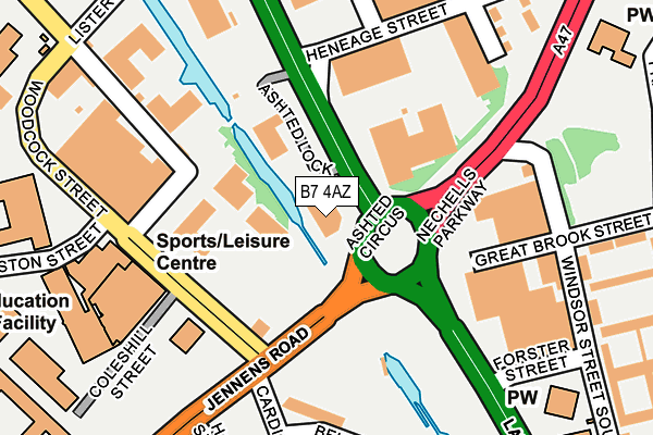
B7 4AZ is located in the Nechells electoral ward, within the metropolitan district of Birmingham and the English Parliamentary constituency of Birmingham, Ladywood. The Sub Integrated Care Board (ICB) Location is NHS Birmingham and Solihull ICB - 15E and the police force is West Midlands. This postcode has been in use since January 1993.


GetTheData
Source: OS OpenMap – Local (Ordnance Survey)
Source: OS VectorMap District (Ordnance Survey)
Licence: Open Government Licence (requires attribution)
| Easting | 407936 |
| Northing | 287698 |
| Latitude | 52.487158 |
| Longitude | -1.884555 |
GetTheData
Source: Open Postcode Geo
Licence: Open Government Licence
| Country | England |
| Postcode District | B7 |
➜ See where B7 is on a map ➜ Where is Birmingham? | |
GetTheData
Source: Land Registry Price Paid Data
Licence: Open Government Licence
Elevation or altitude of B7 4AZ as distance above sea level:
| Metres | Feet | |
|---|---|---|
| Elevation | 120m | 394ft |
Elevation is measured from the approximate centre of the postcode, to the nearest point on an OS contour line from OS Terrain 50, which has contour spacing of ten vertical metres.
➜ How high above sea level am I? Find the elevation of your current position using your device's GPS.
GetTheData
Source: Open Postcode Elevation
Licence: Open Government Licence
| Ward | Nechells |
| Constituency | Birmingham, Ladywood |
GetTheData
Source: ONS Postcode Database
Licence: Open Government Licence
| Aston University (Woodcock St) | Aston University | 158m |
| Aston University (Woodcock St) | Aston University | 170m |
| The Gosta Green (Lister St) | Aston University | 189m |
| Woodcock St (Jennens Rd) | Aston University | 213m |
| The Gosta Green (Lister St) | Aston University | 213m |
| Bull Street (Midland Metro Stop) (Bull Street) | Birmingham | 990m |
| Snow Hill (Midland Metro Stop) (Colmore Row) | Birmingham | 1,068m |
| Corporation Street (Midland Metro Stop) (Corporation Street) | Birmingham | 1,181m |
| St Paul's (Midland Metro Stop) (Livery Street) | Jewellery Quarter | 1,316m |
| Grand Central New Street (Midland Metro Stop) (Stephenson Street) | Birmingham | 1,379m |
| Duddeston Station | 0.9km |
| Birmingham Moor Street Station | 1km |
| Birmingham Snow Hill Station | 1.1km |
GetTheData
Source: NaPTAN
Licence: Open Government Licence
GetTheData
Source: ONS Postcode Database
Licence: Open Government Licence


➜ Get more ratings from the Food Standards Agency
GetTheData
Source: Food Standards Agency
Licence: FSA terms & conditions
| Last Collection | |||
|---|---|---|---|
| Location | Mon-Fri | Sat | Distance |
| Belmont Row/ Lawley St | 17:30 | 12:00 | 475m |
| Aston Road/Pritchett Street | 17:45 | 12:30 | 539m |
| Vauxhall Post Office | 18:30 | 12:30 | 595m |
GetTheData
Source: Dracos
Licence: Creative Commons Attribution-ShareAlike
The below table lists the International Territorial Level (ITL) codes (formerly Nomenclature of Territorial Units for Statistics (NUTS) codes) and Local Administrative Units (LAU) codes for B7 4AZ:
| ITL 1 Code | Name |
|---|---|
| TLG | West Midlands (England) |
| ITL 2 Code | Name |
| TLG3 | West Midlands |
| ITL 3 Code | Name |
| TLG31 | Birmingham |
| LAU 1 Code | Name |
| E08000025 | Birmingham |
GetTheData
Source: ONS Postcode Directory
Licence: Open Government Licence
The below table lists the Census Output Area (OA), Lower Layer Super Output Area (LSOA), and Middle Layer Super Output Area (MSOA) for B7 4AZ:
| Code | Name | |
|---|---|---|
| OA | E00175649 | |
| LSOA | E01033561 | Birmingham 050E |
| MSOA | E02001876 | Birmingham 050 |
GetTheData
Source: ONS Postcode Directory
Licence: Open Government Licence
| B7 4NJ | Windsor Street | 234m |
| B7 4HZ | Windsor Street South | 249m |
| B7 4NF | Heneage Street | 270m |
| B7 4DA | Great Lister Street | 305m |
| B7 4JD | Forster Street | 308m |
| B7 4NQ | Kellett Road | 334m |
| B7 4JA | Windsor Street South | 337m |
| B7 4BS | Great Lister Street | 362m |
| B7 4DE | Lord Street | 381m |
| B7 4ED | Proctor Street | 420m |
GetTheData
Source: Open Postcode Geo; Land Registry Price Paid Data
Licence: Open Government Licence