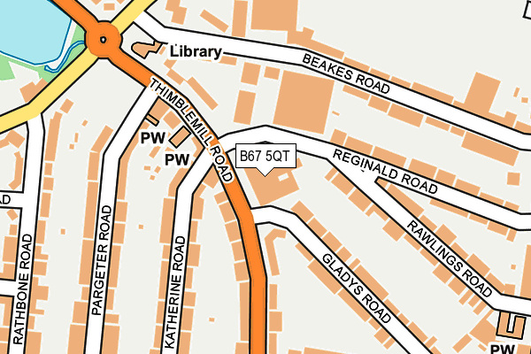
B67 5QT is located in the Abbey electoral ward, within the metropolitan district of Sandwell and the English Parliamentary constituency of Warley. The Sub Integrated Care Board (ICB) Location is NHS Black Country ICB - D2P2L and the police force is West Midlands. This postcode has been in use since January 1980.


GetTheData
Source: OS OpenMap – Local (Ordnance Survey)
Source: OS VectorMap District (Ordnance Survey)
Licence: Open Government Licence (requires attribution)
| Easting | 401861 |
| Northing | 286941 |
| Latitude | 52.480406 |
| Longitude | -1.974021 |
GetTheData
Source: Open Postcode Geo
Licence: Open Government Licence
| Country | England |
| Postcode District | B67 |
➜ See where B67 is on a map ➜ Where is Smethwick? | |
GetTheData
Source: Land Registry Price Paid Data
Licence: Open Government Licence
Elevation or altitude of B67 5QT as distance above sea level:
| Metres | Feet | |
|---|---|---|
| Elevation | 170m | 558ft |
Elevation is measured from the approximate centre of the postcode, to the nearest point on an OS contour line from OS Terrain 50, which has contour spacing of ten vertical metres.
➜ How high above sea level am I? Find the elevation of your current position using your device's GPS.
GetTheData
Source: Open Postcode Elevation
Licence: Open Government Licence
| Ward | Abbey |
| Constituency | Warley |
GetTheData
Source: ONS Postcode Database
Licence: Open Government Licence
| Swimming Baths (Thimblemill Rd) | Bearwood | 80m |
| Thimblemill Baths (Thimblemill Rd) | Bearwood | 109m |
| Mill Hill (Stanhope Rd) | Bearwood | 246m |
| Three Shires Oak Rd (Thimblemill Rd) | Bearwood | 276m |
| Rathbone Rd (Norman Rd) | Bearwood | 283m |
| Smethwick Rolfe Street Station | 1.8km |
| Smethwick Galton Bridge Station | 2.4km |
| Langley Green Station | 2.6km |
GetTheData
Source: NaPTAN
Licence: Open Government Licence
GetTheData
Source: ONS Postcode Database
Licence: Open Government Licence


➜ Get more ratings from the Food Standards Agency
GetTheData
Source: Food Standards Agency
Licence: FSA terms & conditions
| Last Collection | |||
|---|---|---|---|
| Location | Mon-Fri | Sat | Distance |
| Thimblemill Post Office | 18:30 | 12:00 | 162m |
| Abbey Road | 17:30 | 12:00 | 323m |
| Bearwood Road Bet Talbot Road &lin | 17:30 | 12:00 | 328m |
GetTheData
Source: Dracos
Licence: Creative Commons Attribution-ShareAlike
The below table lists the International Territorial Level (ITL) codes (formerly Nomenclature of Territorial Units for Statistics (NUTS) codes) and Local Administrative Units (LAU) codes for B67 5QT:
| ITL 1 Code | Name |
|---|---|
| TLG | West Midlands (England) |
| ITL 2 Code | Name |
| TLG3 | West Midlands |
| ITL 3 Code | Name |
| TLG37 | Sandwell |
| LAU 1 Code | Name |
| E08000028 | Sandwell |
GetTheData
Source: ONS Postcode Directory
Licence: Open Government Licence
The below table lists the Census Output Area (OA), Lower Layer Super Output Area (LSOA), and Middle Layer Super Output Area (MSOA) for B67 5QT:
| Code | Name | |
|---|---|---|
| OA | E00050189 | |
| LSOA | E01009928 | Sandwell 034G |
| MSOA | E02002076 | Sandwell 034 |
GetTheData
Source: ONS Postcode Directory
Licence: Open Government Licence
| B67 5AF | Reginald Road | 75m |
| B67 5QS | Thimblemill Road | 101m |
| B67 5AW | Gladys Road | 119m |
| B67 5QY | Katherine Road | 135m |
| B67 5RG | Thimblemill Road | 150m |
| B67 5RF | Katherine Road | 151m |
| B67 5RS | Beakes Road | 154m |
| B67 5AD | Rawlings Road | 158m |
| B67 5QP | Thimblemill Road | 179m |
| B67 5RN | Beakes Road | 179m |
GetTheData
Source: Open Postcode Geo; Land Registry Price Paid Data
Licence: Open Government Licence