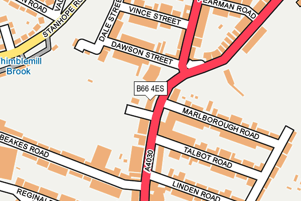
B66 4ES lies on Bearwood Road in Smethwick. B66 4ES is located in the Abbey electoral ward, within the metropolitan district of Sandwell and the English Parliamentary constituency of Warley. The Sub Integrated Care Board (ICB) Location is NHS Black Country ICB - D2P2L and the police force is West Midlands. This postcode has been in use since January 1980.


GetTheData
Source: OS OpenMap – Local (Ordnance Survey)
Source: OS VectorMap District (Ordnance Survey)
Licence: Open Government Licence (requires attribution)
| Easting | 402174 |
| Northing | 287134 |
| Latitude | 52.482125 |
| Longitude | -1.969417 |
GetTheData
Source: Open Postcode Geo
Licence: Open Government Licence
| Street | Bearwood Road |
| Town/City | Smethwick |
| Country | England |
| Postcode District | B66 |
➜ See where B66 is on a map ➜ Where is Smethwick? | |
GetTheData
Source: Land Registry Price Paid Data
Licence: Open Government Licence
Elevation or altitude of B66 4ES as distance above sea level:
| Metres | Feet | |
|---|---|---|
| Elevation | 170m | 558ft |
Elevation is measured from the approximate centre of the postcode, to the nearest point on an OS contour line from OS Terrain 50, which has contour spacing of ten vertical metres.
➜ How high above sea level am I? Find the elevation of your current position using your device's GPS.
GetTheData
Source: Open Postcode Elevation
Licence: Open Government Licence
| Ward | Abbey |
| Constituency | Warley |
GetTheData
Source: ONS Postcode Database
Licence: Open Government Licence
| The Barleycorn (Bearwood Rd) | Bearwood | 27m |
| The Barleycorn (Bearwood Rd) | Bearwood | 40m |
| The Barleycorn (Bearwood Rd) | Bearwood | 48m |
| Richmond Rd (Bearwood Rd) | Bearwood | 188m |
| Richmond Rd (Bearwood Rd) | Bearwood | 239m |
| Smethwick Rolfe Street Station | 1.6km |
| Smethwick Galton Bridge Station | 2.3km |
| The Hawthorns Station | 2.6km |
GetTheData
Source: NaPTAN
Licence: Open Government Licence
Estimated total energy consumption in B66 4ES by fuel type, 2015.
| Consumption (kWh) | 136,358 |
|---|---|
| Meter count | 9 |
| Mean (kWh/meter) | 15,151 |
| Median (kWh/meter) | 3,917 |
GetTheData
Source: Postcode level gas estimates: 2015 (experimental)
Source: Postcode level electricity estimates: 2015 (experimental)
Licence: Open Government Licence
GetTheData
Source: ONS Postcode Database
Licence: Open Government Licence


➜ Get more ratings from the Food Standards Agency
GetTheData
Source: Food Standards Agency
Licence: FSA terms & conditions
| Last Collection | |||
|---|---|---|---|
| Location | Mon-Fri | Sat | Distance |
| Bearwood Road Bet Talbot Road &lin | 17:30 | 12:00 | 113m |
| Davison Road / Astbury Road | 17:30 | 12:00 | 393m |
| Grange Road / Bearwood Road | 17:30 | 12:00 | 395m |
GetTheData
Source: Dracos
Licence: Creative Commons Attribution-ShareAlike
The below table lists the International Territorial Level (ITL) codes (formerly Nomenclature of Territorial Units for Statistics (NUTS) codes) and Local Administrative Units (LAU) codes for B66 4ES:
| ITL 1 Code | Name |
|---|---|
| TLG | West Midlands (England) |
| ITL 2 Code | Name |
| TLG3 | West Midlands |
| ITL 3 Code | Name |
| TLG37 | Sandwell |
| LAU 1 Code | Name |
| E08000028 | Sandwell |
GetTheData
Source: ONS Postcode Directory
Licence: Open Government Licence
The below table lists the Census Output Area (OA), Lower Layer Super Output Area (LSOA), and Middle Layer Super Output Area (MSOA) for B66 4ES:
| Code | Name | |
|---|---|---|
| OA | E00050185 | |
| LSOA | E01009928 | Sandwell 034G |
| MSOA | E02002076 | Sandwell 034 |
GetTheData
Source: ONS Postcode Directory
Licence: Open Government Licence
| B66 4DR | Bearwood Road | 51m |
| B66 4JB | Dawson Street | 111m |
| B66 4DP | Bearwood Road | 111m |
| B66 4ET | Bearwood Road | 118m |
| B66 4HT | Bearwood Road | 152m |
| B66 4NA | Bearwood Road | 160m |
| B66 4HY | Dale Street | 161m |
| B66 4DW | Marlborough Road | 163m |
| B66 4DX | Talbot Road | 168m |
| B66 4DN | Marlborough Road | 171m |
GetTheData
Source: Open Postcode Geo; Land Registry Price Paid Data
Licence: Open Government Licence