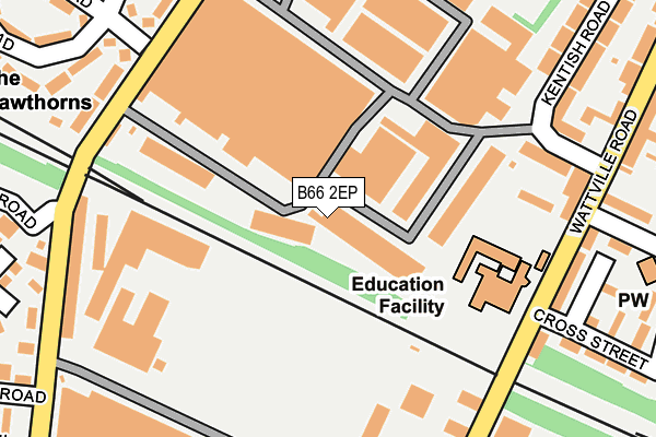
B66 2EP lies on Middlemore Road in Middlemore Industrial Estate, Smethwick. B66 2EP is located in the Holyhead electoral ward, within the metropolitan district of Birmingham and the English Parliamentary constituency of Birmingham, Ladywood. The Sub Integrated Care Board (ICB) Location is NHS Birmingham and Solihull ICB - 15E and the police force is West Midlands. This postcode has been in use since January 1980.


GetTheData
Source: OS OpenMap – Local (Ordnance Survey)
Source: OS VectorMap District (Ordnance Survey)
Licence: Open Government Licence (requires attribution)
| Easting | 402886 |
| Northing | 289690 |
| Latitude | 52.505115 |
| Longitude | -1.958906 |
GetTheData
Source: Open Postcode Geo
Licence: Open Government Licence
| Street | Middlemore Road |
| Locality | Middlemore Industrial Estate |
| Town/City | Smethwick |
| Country | England |
| Postcode District | B66 |
➜ See where B66 is on a map ➜ Where is Birmingham? | |
GetTheData
Source: Land Registry Price Paid Data
Licence: Open Government Licence
Elevation or altitude of B66 2EP as distance above sea level:
| Metres | Feet | |
|---|---|---|
| Elevation | 150m | 492ft |
Elevation is measured from the approximate centre of the postcode, to the nearest point on an OS contour line from OS Terrain 50, which has contour spacing of ten vertical metres.
➜ How high above sea level am I? Find the elevation of your current position using your device's GPS.
GetTheData
Source: Open Postcode Elevation
Licence: Open Government Licence
| Ward | Holyhead |
| Constituency | Birmingham, Ladywood |
GetTheData
Source: ONS Postcode Database
Licence: Open Government Licence
| Junction Rd (Wattville Rd) | Handsworth | 192m |
| Junction Rd (Wattville Rd) | Handsworth | 193m |
| Island Rd (Holyhead Rd) | Leveretts | 468m |
| Island Rd (Holyhead Rd) | Leveretts | 488m |
| Holyhead Rd (Austin Rd) | Handsworth | 489m |
| The Hawthorns (Midland Metro Stop) (Middlemore Lane) | Smethwick | 395m |
| Handsworth Booth Street (Midland Metro Stop) (Booth Street) | Handsworth | 575m |
| Winson Green Outer Circle (Midland Metro Stop) (Boulton Road) | Winson Green | 1,537m |
| The Hawthorns Station | 0.3km |
| Smethwick Rolfe Street Station | 1.3km |
| Smethwick Galton Bridge Station | 1.5km |
GetTheData
Source: NaPTAN
Licence: Open Government Licence
Estimated total energy consumption in B66 2EP by fuel type, 2015.
| Consumption (kWh) | 151,305 |
|---|---|
| Meter count | 7 |
| Mean (kWh/meter) | 21,615 |
| Median (kWh/meter) | 4,362 |
GetTheData
Source: Postcode level gas estimates: 2015 (experimental)
Source: Postcode level electricity estimates: 2015 (experimental)
Licence: Open Government Licence
GetTheData
Source: ONS Postcode Database
Licence: Open Government Licence


➜ Get more ratings from the Food Standards Agency
GetTheData
Source: Food Standards Agency
Licence: FSA terms & conditions
| Last Collection | |||
|---|---|---|---|
| Location | Mon-Fri | Sat | Distance |
| Junction Road / George St | 17:30 | 12:30 | 296m |
| St Stephens Road / Albion Road | 17:30 | 12:00 | 299m |
| Watville Road Post Office | 17:30 | 12:30 | 492m |
GetTheData
Source: Dracos
Licence: Creative Commons Attribution-ShareAlike
The below table lists the International Territorial Level (ITL) codes (formerly Nomenclature of Territorial Units for Statistics (NUTS) codes) and Local Administrative Units (LAU) codes for B66 2EP:
| ITL 1 Code | Name |
|---|---|
| TLG | West Midlands (England) |
| ITL 2 Code | Name |
| TLG3 | West Midlands |
| ITL 3 Code | Name |
| TLG31 | Birmingham |
| LAU 1 Code | Name |
| E08000025 | Birmingham |
GetTheData
Source: ONS Postcode Directory
Licence: Open Government Licence
The below table lists the Census Output Area (OA), Lower Layer Super Output Area (LSOA), and Middle Layer Super Output Area (MSOA) for B66 2EP:
| Code | Name | |
|---|---|---|
| OA | E00047427 | |
| LSOA | E01009349 | Birmingham 036D |
| MSOA | E02001862 | Birmingham 036 |
GetTheData
Source: ONS Postcode Directory
Licence: Open Government Licence
| B21 0AY | Middlemore Road | 44m |
| B21 0BA | Kentish Road | 153m |
| B21 0DP | Wattville Road | 173m |
| B21 0DN | Wattville Road | 204m |
| B21 0EL | Junction Road | 226m |
| B21 0HE | Peasefield Close | 235m |
| B21 0BB | Kentish Road | 237m |
| B21 0AX | Kentish Road | 246m |
| B21 0DL | Wattville Road | 247m |
| B71 4LS | Middlemore Road | 251m |
GetTheData
Source: Open Postcode Geo; Land Registry Price Paid Data
Licence: Open Government Licence