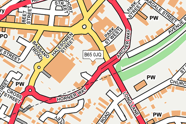
B65 0JQ is located in the Blackheath electoral ward, within the metropolitan district of Sandwell and the English Parliamentary constituency of Halesowen and Rowley Regis. The Sub Integrated Care Board (ICB) Location is NHS Black Country ICB - D2P2L and the police force is West Midlands. This postcode has been in use since December 2009.


GetTheData
Source: OS OpenMap – Local (Ordnance Survey)
Source: OS VectorMap District (Ordnance Survey)
Licence: Open Government Licence (requires attribution)
| Easting | 397492 |
| Northing | 286292 |
| Latitude | 52.474553 |
| Longitude | -2.038352 |
GetTheData
Source: Open Postcode Geo
Licence: Open Government Licence
| Country | England |
| Postcode District | B65 |
➜ See where B65 is on a map ➜ Where is Blackheath? | |
GetTheData
Source: Land Registry Price Paid Data
Licence: Open Government Licence
Elevation or altitude of B65 0JQ as distance above sea level:
| Metres | Feet | |
|---|---|---|
| Elevation | 180m | 591ft |
Elevation is measured from the approximate centre of the postcode, to the nearest point on an OS contour line from OS Terrain 50, which has contour spacing of ten vertical metres.
➜ How high above sea level am I? Find the elevation of your current position using your device's GPS.
GetTheData
Source: Open Postcode Elevation
Licence: Open Government Licence
| Ward | Blackheath |
| Constituency | Halesowen And Rowley Regis |
GetTheData
Source: ONS Postcode Database
Licence: Open Government Licence
| Blackheath Market (Long Lane) | Blackheath | 47m |
| Blackheath Market (Long Lane) | Blackheath | 119m |
| Sainsburys (Halesowen St) | Blackheath | 127m |
| Barclays Bank (Birmingham Rd) | Blackheath | 191m |
| Green Lane (Long Lane) | Hurst Green | 213m |
| Rowley Regis Station | 0.6km |
| Old Hill Station | 1.3km |
| Langley Green Station | 3.1km |
GetTheData
Source: NaPTAN
Licence: Open Government Licence
GetTheData
Source: ONS Postcode Database
Licence: Open Government Licence


➜ Get more ratings from the Food Standards Agency
GetTheData
Source: Food Standards Agency
Licence: FSA terms & conditions
| Last Collection | |||
|---|---|---|---|
| Location | Mon-Fri | Sat | Distance |
| Vicarage Road / Long Lane | 17:15 | 12:00 | 150m |
| Black Heath Post Office | 17:30 | 12:00 | 283m |
| The Crescent / Regis Road | 17:30 | 12:00 | 500m |
GetTheData
Source: Dracos
Licence: Creative Commons Attribution-ShareAlike
The below table lists the International Territorial Level (ITL) codes (formerly Nomenclature of Territorial Units for Statistics (NUTS) codes) and Local Administrative Units (LAU) codes for B65 0JQ:
| ITL 1 Code | Name |
|---|---|
| TLG | West Midlands (England) |
| ITL 2 Code | Name |
| TLG3 | West Midlands |
| ITL 3 Code | Name |
| TLG37 | Sandwell |
| LAU 1 Code | Name |
| E08000028 | Sandwell |
GetTheData
Source: ONS Postcode Directory
Licence: Open Government Licence
The below table lists the Census Output Area (OA), Lower Layer Super Output Area (LSOA), and Middle Layer Super Output Area (MSOA) for B65 0JQ:
| Code | Name | |
|---|---|---|
| OA | E00050249 | |
| LSOA | E01009932 | Sandwell 033D |
| MSOA | E02002075 | Sandwell 033 |
GetTheData
Source: ONS Postcode Directory
Licence: Open Government Licence
| B65 0JE | Long Lane | 70m |
| B65 0HG | Halesowen Street | 103m |
| B65 0ES | Halesowen Street | 136m |
| B65 0DT | High Street | 154m |
| B65 0JN | Oldbury Road | 171m |
| B62 8HX | Vicarage Road | 184m |
| B62 8HJ | Upper Ashley Street | 200m |
| B65 0DX | High Street | 215m |
| B62 9LL | Long Lane | 223m |
| B65 0LR | Avenue Road | 227m |
GetTheData
Source: Open Postcode Geo; Land Registry Price Paid Data
Licence: Open Government Licence