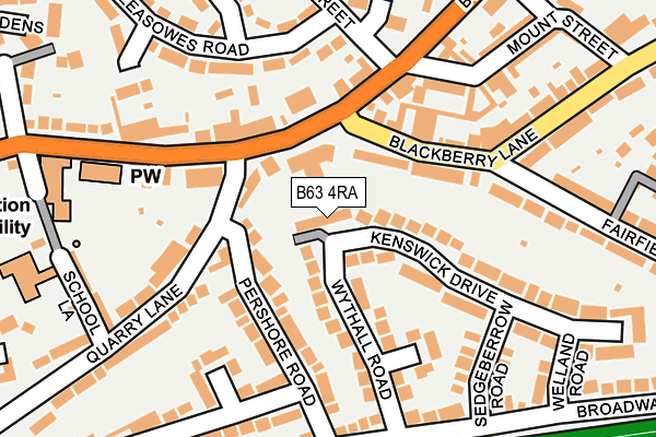
B63 4RA lies on Kenswick Drive in Halesowen. B63 4RA is located in the Halesowen South electoral ward, within the metropolitan district of Dudley and the English Parliamentary constituency of Halesowen and Rowley Regis. The Sub Integrated Care Board (ICB) Location is NHS Black Country ICB - D2P2L and the police force is West Midlands. This postcode has been in use since January 1980.


GetTheData
Source: OS OpenMap – Local (Ordnance Survey)
Source: OS VectorMap District (Ordnance Survey)
Licence: Open Government Licence (requires attribution)
| Easting | 396180 |
| Northing | 282860 |
| Latitude | 52.443706 |
| Longitude | -2.057621 |
GetTheData
Source: Open Postcode Geo
Licence: Open Government Licence
| Street | Kenswick Drive |
| Town/City | Halesowen |
| Country | England |
| Postcode District | B63 |
➜ See where B63 is on a map ➜ Where is Halesowen? | |
GetTheData
Source: Land Registry Price Paid Data
Licence: Open Government Licence
Elevation or altitude of B63 4RA as distance above sea level:
| Metres | Feet | |
|---|---|---|
| Elevation | 150m | 492ft |
Elevation is measured from the approximate centre of the postcode, to the nearest point on an OS contour line from OS Terrain 50, which has contour spacing of ten vertical metres.
➜ How high above sea level am I? Find the elevation of your current position using your device's GPS.
GetTheData
Source: Open Postcode Elevation
Licence: Open Government Licence
| Ward | Halesowen South |
| Constituency | Halesowen And Rowley Regis |
GetTheData
Source: ONS Postcode Database
Licence: Open Government Licence
| Blackberry Lane (Hagley Rd) | Halesowen | 72m |
| Blackberry Lane (Hagley Rd) | Halesowen | 90m |
| Uffmoor Golf Course (Manor Way) | Halesowen | 259m |
| School Lane (Hagley Rd) | Hasbury | 346m |
| School Lane (Hagley Rd) | Hasbury | 364m |
| Old Hill Station | 3km |
| Cradley Heath Station | 3.7km |
| Rowley Regis Station | 4.2km |
GetTheData
Source: NaPTAN
Licence: Open Government Licence
| Median download speed | 33.0Mbps |
| Average download speed | 45.3Mbps |
| Maximum download speed | 79.98Mbps |
| Median upload speed | 10.0Mbps |
| Average upload speed | 11.7Mbps |
| Maximum upload speed | 20.00Mbps |
GetTheData
Source: Ofcom
Licence: Ofcom Terms of Use (requires attribution)
Estimated total energy consumption in B63 4RA by fuel type, 2015.
| Consumption (kWh) | 121,397 |
|---|---|
| Meter count | 17 |
| Mean (kWh/meter) | 7,141 |
| Median (kWh/meter) | 6,210 |
| Consumption (kWh) | 35,542 |
|---|---|
| Meter count | 15 |
| Mean (kWh/meter) | 2,369 |
| Median (kWh/meter) | 2,239 |
GetTheData
Source: Postcode level gas estimates: 2015 (experimental)
Source: Postcode level electricity estimates: 2015 (experimental)
Licence: Open Government Licence
GetTheData
Source: ONS Postcode Database
Licence: Open Government Licence


➜ Get more ratings from the Food Standards Agency
GetTheData
Source: Food Standards Agency
Licence: FSA terms & conditions
| Last Collection | |||
|---|---|---|---|
| Location | Mon-Fri | Sat | Distance |
| Hasbury Post Office | 17:15 | 12:00 | 81m |
| Hill St | 17:30 | 12:00 | 348m |
| Elizabeth Road / High Farm Road | 17:15 | 12:00 | 564m |
GetTheData
Source: Dracos
Licence: Creative Commons Attribution-ShareAlike
The below table lists the International Territorial Level (ITL) codes (formerly Nomenclature of Territorial Units for Statistics (NUTS) codes) and Local Administrative Units (LAU) codes for B63 4RA:
| ITL 1 Code | Name |
|---|---|
| TLG | West Midlands (England) |
| ITL 2 Code | Name |
| TLG3 | West Midlands |
| ITL 3 Code | Name |
| TLG36 | Dudley |
| LAU 1 Code | Name |
| E08000027 | Dudley |
GetTheData
Source: ONS Postcode Directory
Licence: Open Government Licence
The below table lists the Census Output Area (OA), Lower Layer Super Output Area (LSOA), and Middle Layer Super Output Area (MSOA) for B63 4RA:
| Code | Name | |
|---|---|---|
| OA | E00049598 | |
| LSOA | E01009799 | Dudley 039D |
| MSOA | E02002038 | Dudley 039 |
GetTheData
Source: ONS Postcode Directory
Licence: Open Government Licence
| B63 4NX | Blackberry Lane | 68m |
| B63 4QB | Hagley Road | 70m |
| B63 4PA | Quarry Lane | 72m |
| B63 4QJ | Pershore Road | 98m |
| B63 4QR | Wythall Road | 109m |
| B63 4RB | Kenswick Drive | 133m |
| B63 4QA | Hagley Road | 135m |
| B63 4QZ | Kenswick Drive | 139m |
| B63 4QQ | Hagley Road | 141m |
| B63 4SE | Red Leasowes Road | 152m |
GetTheData
Source: Open Postcode Geo; Land Registry Price Paid Data
Licence: Open Government Licence