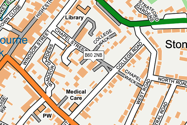
B60 2NB lies on College Road in Bromsgrove. B60 2NB is located in the Bromsgrove Central electoral ward, within the local authority district of Bromsgrove and the English Parliamentary constituency of Bromsgrove. The Sub Integrated Care Board (ICB) Location is NHS Herefordshire and Worcestershire ICB - 18C and the police force is West Mercia. This postcode has been in use since March 2007.


GetTheData
Source: OS OpenMap – Local (Ordnance Survey)
Source: OS VectorMap District (Ordnance Survey)
Licence: Open Government Licence (requires attribution)
| Easting | 396189 |
| Northing | 270679 |
| Latitude | 52.334196 |
| Longitude | -2.057345 |
GetTheData
Source: Open Postcode Geo
Licence: Open Government Licence
| Street | College Road |
| Town/City | Bromsgrove |
| Country | England |
| Postcode District | B60 |
➜ See where B60 is on a map ➜ Where is Bromsgrove? | |
GetTheData
Source: Land Registry Price Paid Data
Licence: Open Government Licence
Elevation or altitude of B60 2NB as distance above sea level:
| Metres | Feet | |
|---|---|---|
| Elevation | 100m | 328ft |
Elevation is measured from the approximate centre of the postcode, to the nearest point on an OS contour line from OS Terrain 50, which has contour spacing of ten vertical metres.
➜ How high above sea level am I? Find the elevation of your current position using your device's GPS.
GetTheData
Source: Open Postcode Elevation
Licence: Open Government Licence
| Ward | Bromsgrove Central |
| Constituency | Bromsgrove |
GetTheData
Source: ONS Postcode Database
Licence: Open Government Licence
| Windsor Street (New Road) | Bromsgrove | 205m |
| Windsor Street (New Road) | Bromsgrove | 210m |
| Sunnymead (New Road) | Bromsgrove | 232m |
| Sunnymead (New Road) | Bromsgrove | 238m |
| Stratford Road | Bromsgrove | 284m |
| Bromsgrove Station | 1.5km |
| Barnt Green Station | 5.3km |
GetTheData
Source: NaPTAN
Licence: Open Government Licence
| Median download speed | 57.6Mbps |
| Average download speed | 46.2Mbps |
| Maximum download speed | 80.00Mbps |
| Median upload speed | 15.0Mbps |
| Average upload speed | 12.3Mbps |
| Maximum upload speed | 20.00Mbps |
GetTheData
Source: Ofcom
Licence: Ofcom Terms of Use (requires attribution)
Estimated total energy consumption in B60 2NB by fuel type, 2015.
| Consumption (kWh) | 117,127 |
|---|---|
| Meter count | 23 |
| Mean (kWh/meter) | 5,092 |
| Median (kWh/meter) | 5,301 |
GetTheData
Source: Postcode level gas estimates: 2015 (experimental)
Source: Postcode level electricity estimates: 2015 (experimental)
Licence: Open Government Licence
GetTheData
Source: ONS Postcode Database
Licence: Open Government Licence


➜ Get more ratings from the Food Standards Agency
GetTheData
Source: Food Standards Agency
Licence: FSA terms & conditions
| Last Collection | |||
|---|---|---|---|
| Location | Mon-Fri | Sat | Distance |
| Cottage Hospital New Road | 17:30 | 12:00 | 194m |
| Bromsgrove Post Office | 18:15 | 12:30 | 264m |
| Bromsgrove Post Office | 18:15 | 272m | |
GetTheData
Source: Dracos
Licence: Creative Commons Attribution-ShareAlike
The below table lists the International Territorial Level (ITL) codes (formerly Nomenclature of Territorial Units for Statistics (NUTS) codes) and Local Administrative Units (LAU) codes for B60 2NB:
| ITL 1 Code | Name |
|---|---|
| TLG | West Midlands (England) |
| ITL 2 Code | Name |
| TLG1 | Herefordshire, Worcestershire and Warwickshire |
| ITL 3 Code | Name |
| TLG12 | Worcestershire CC |
| LAU 1 Code | Name |
| E07000234 | Bromsgrove |
GetTheData
Source: ONS Postcode Directory
Licence: Open Government Licence
The below table lists the Census Output Area (OA), Lower Layer Super Output Area (LSOA), and Middle Layer Super Output Area (MSOA) for B60 2NB:
| Code | Name | |
|---|---|---|
| OA | E00164014 | |
| LSOA | E01032157 | Bromsgrove 011B |
| MSOA | E02006706 | Bromsgrove 011 |
GetTheData
Source: ONS Postcode Directory
Licence: Open Government Licence
| B60 2NE | College Road | 37m |
| B60 2BQ | Chapel Street | 77m |
| B60 2ND | College Walk | 106m |
| B60 2NF | College Road | 125m |
| B60 1AP | Stratford Road | 156m |
| B60 2JL | New Road | 157m |
| B60 2JQ | New Road | 158m |
| B60 2JG | New Road | 176m |
| B60 2NG | West Road | 179m |
| B60 1AS | Stratford Road | 188m |
GetTheData
Source: Open Postcode Geo; Land Registry Price Paid Data
Licence: Open Government Licence