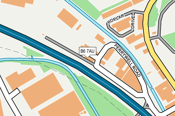
B6 7AU lies on Chancel Way Industrial Estate in Birmingham. B6 7AU is located in the Perry Barr electoral ward, within the metropolitan district of Birmingham and the English Parliamentary constituency of Birmingham, Perry Barr. The Sub Integrated Care Board (ICB) Location is NHS Birmingham and Solihull ICB - 15E and the police force is West Midlands. This postcode has been in use since June 1981.


GetTheData
Source: OS OpenMap – Local (Ordnance Survey)
Source: OS VectorMap District (Ordnance Survey)
Licence: Open Government Licence (requires attribution)
| Easting | 407802 |
| Northing | 292039 |
| Latitude | 52.526185 |
| Longitude | -1.886427 |
GetTheData
Source: Open Postcode Geo
Licence: Open Government Licence
| Street | Chancel Way Industrial Estate |
| Town/City | Birmingham |
| Country | England |
| Postcode District | B6 |
➜ See where B6 is on a map ➜ Where is Birmingham? | |
GetTheData
Source: Land Registry Price Paid Data
Licence: Open Government Licence
Elevation or altitude of B6 7AU as distance above sea level:
| Metres | Feet | |
|---|---|---|
| Elevation | 100m | 328ft |
Elevation is measured from the approximate centre of the postcode, to the nearest point on an OS contour line from OS Terrain 50, which has contour spacing of ten vertical metres.
➜ How high above sea level am I? Find the elevation of your current position using your device's GPS.
GetTheData
Source: Open Postcode Elevation
Licence: Open Government Licence
| Ward | Perry Barr |
| Constituency | Birmingham, Perry Barr |
GetTheData
Source: ONS Postcode Database
Licence: Open Government Licence
UNIT 9, CHANCEL WAY INDUSTRIAL ESTATE, BIRMINGHAM, B6 7AU 2009 11 NOV £60,000 |
GetTheData
Source: HM Land Registry Price Paid Data
Licence: Contains HM Land Registry data © Crown copyright and database right 2025. This data is licensed under the Open Government Licence v3.0.
| Kingstanding Rd (College Rd) | Perry Common | 562m |
| Gipsy Lane (The Ridgeway) | Perry Common | 572m |
| Kingstanding Rd (College Rd) | Perry Common | 579m |
| Gipsy Lane (The Ridgeway) | Perry Common | 579m |
| Elmbridge Rd (Kingstanding Rd) | Perry Common | 644m |
| Perry Barr Station | 1.5km |
| Witton (West Midlands) Station | 1.5km |
| Gravelly Hill Station | 2.6km |
GetTheData
Source: NaPTAN
Licence: Open Government Licence
GetTheData
Source: ONS Postcode Database
Licence: Open Government Licence


➜ Get more ratings from the Food Standards Agency
GetTheData
Source: Food Standards Agency
Licence: FSA terms & conditions
| Last Collection | |||
|---|---|---|---|
| Location | Mon-Fri | Sat | Distance |
| Moor Lane | 18:30 | 12:30 | 196m |
| Kingstanding Road / College Road | 17:30 | 12:30 | 584m |
| Ansells House Tame Bridge Hous | 17:30 | 12:30 | 713m |
GetTheData
Source: Dracos
Licence: Creative Commons Attribution-ShareAlike
The below table lists the International Territorial Level (ITL) codes (formerly Nomenclature of Territorial Units for Statistics (NUTS) codes) and Local Administrative Units (LAU) codes for B6 7AU:
| ITL 1 Code | Name |
|---|---|
| TLG | West Midlands (England) |
| ITL 2 Code | Name |
| TLG3 | West Midlands |
| ITL 3 Code | Name |
| TLG31 | Birmingham |
| LAU 1 Code | Name |
| E08000025 | Birmingham |
GetTheData
Source: ONS Postcode Directory
Licence: Open Government Licence
The below table lists the Census Output Area (OA), Lower Layer Super Output Area (LSOA), and Middle Layer Super Output Area (MSOA) for B6 7AU:
| Code | Name | |
|---|---|---|
| OA | E00046855 | |
| LSOA | E01009239 | Birmingham 033F |
| MSOA | E02001859 | Birmingham 033 |
GetTheData
Source: ONS Postcode Directory
Licence: Open Government Licence
| B6 7AD | Poplar Drive | 170m |
| B6 7AT | Moor Lane Trading Estate | 188m |
| B6 7AE | Moor Lane | 250m |
| B6 7AF | Gavin Way | 442m |
| B44 8DP | College Road | 588m |
| B23 7TE | The Ridgeway | 597m |
| B44 8DA | College Road | 623m |
| B23 7SY | Ipsley Grove | 645m |
| B23 7TA | The Ridgeway | 648m |
| B23 7TF | Mellis Grove | 648m |
GetTheData
Source: Open Postcode Geo; Land Registry Price Paid Data
Licence: Open Government Licence