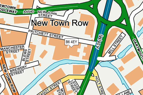
B6 4EY is located in the Newtown electoral ward, within the metropolitan district of Birmingham and the English Parliamentary constituency of Birmingham, Ladywood. The Sub Integrated Care Board (ICB) Location is NHS Birmingham and Solihull ICB - 15E and the police force is West Midlands. This postcode has been in use since January 1980.


GetTheData
Source: OS OpenMap – Local (Ordnance Survey)
Source: OS VectorMap District (Ordnance Survey)
Licence: Open Government Licence (requires attribution)
| Easting | 407513 |
| Northing | 288109 |
| Latitude | 52.490844 |
| Longitude | -1.890780 |
GetTheData
Source: Open Postcode Geo
Licence: Open Government Licence
| Country | England |
| Postcode District | B6 |
➜ See where B6 is on a map ➜ Where is Birmingham? | |
GetTheData
Source: Land Registry Price Paid Data
Licence: Open Government Licence
Elevation or altitude of B6 4EY as distance above sea level:
| Metres | Feet | |
|---|---|---|
| Elevation | 120m | 394ft |
Elevation is measured from the approximate centre of the postcode, to the nearest point on an OS contour line from OS Terrain 50, which has contour spacing of ten vertical metres.
➜ How high above sea level am I? Find the elevation of your current position using your device's GPS.
GetTheData
Source: Open Postcode Elevation
Licence: Open Government Licence
| Ward | Newtown |
| Constituency | Birmingham, Ladywood |
GetTheData
Source: ONS Postcode Database
Licence: Open Government Licence
| Bagot St (Corporation St) | Aston University | 138m |
| Bagot St (Corporation St) | Aston University | 166m |
| Dartmouth Circus (Aston Bridge) | Aston | 270m |
| Lower Tower St (Newtown Row) | Aston University | 305m |
| Lower Tower St (Newtown Row) | Aston University | 315m |
| Snow Hill (Midland Metro Stop) (Colmore Row) | Birmingham | 988m |
| St Paul's (Midland Metro Stop) (Livery Street) | Jewellery Quarter | 1,007m |
| Bull Street (Midland Metro Stop) (Bull Street) | Birmingham | 1,067m |
| Corporation Street (Midland Metro Stop) (Corporation Street) | Birmingham | 1,298m |
| Grand Central New Street (Midland Metro Stop) (Stephenson Street) | Birmingham | 1,478m |
| Birmingham Snow Hill Station | 1km |
| Birmingham Moor Street Station | 1.3km |
| Duddeston Station | 1.3km |
GetTheData
Source: NaPTAN
Licence: Open Government Licence
GetTheData
Source: ONS Postcode Database
Licence: Open Government Licence


➜ Get more ratings from the Food Standards Agency
GetTheData
Source: Food Standards Agency
Licence: FSA terms & conditions
| Last Collection | |||
|---|---|---|---|
| Location | Mon-Fri | Sat | Distance |
| Aston Road/Pritchett Street | 17:45 | 12:30 | 93m |
| Thomas Street | 17:30 | 12:30 | 542m |
| Princip St / Loveday St | 18:30 | 12:30 | 547m |
GetTheData
Source: Dracos
Licence: Creative Commons Attribution-ShareAlike
The below table lists the International Territorial Level (ITL) codes (formerly Nomenclature of Territorial Units for Statistics (NUTS) codes) and Local Administrative Units (LAU) codes for B6 4EY:
| ITL 1 Code | Name |
|---|---|
| TLG | West Midlands (England) |
| ITL 2 Code | Name |
| TLG3 | West Midlands |
| ITL 3 Code | Name |
| TLG31 | Birmingham |
| LAU 1 Code | Name |
| E08000025 | Birmingham |
GetTheData
Source: ONS Postcode Directory
Licence: Open Government Licence
The below table lists the Census Output Area (OA), Lower Layer Super Output Area (LSOA), and Middle Layer Super Output Area (MSOA) for B6 4EY:
| Code | Name | |
|---|---|---|
| OA | E00175794 | |
| LSOA | E01008914 | Birmingham 050C |
| MSOA | E02001876 | Birmingham 050 |
GetTheData
Source: ONS Postcode Directory
Licence: Open Government Licence
| B6 4ES | Pritchett Street | 100m |
| B6 4LD | New John Street | 126m |
| B6 4EP | Blews Street | 163m |
| B6 4HN | Blews Street | 213m |
| B4 7BA | Bagot Street | 259m |
| B4 7DP | Corporation Street | 316m |
| B6 4HP | New Town Row | 348m |
| B6 4NH | Miller Street | 350m |
| B4 6LN | Princip Street | 427m |
| B19 3NZ | Shillcock Grove | 428m |
GetTheData
Source: Open Postcode Geo; Land Registry Price Paid Data
Licence: Open Government Licence