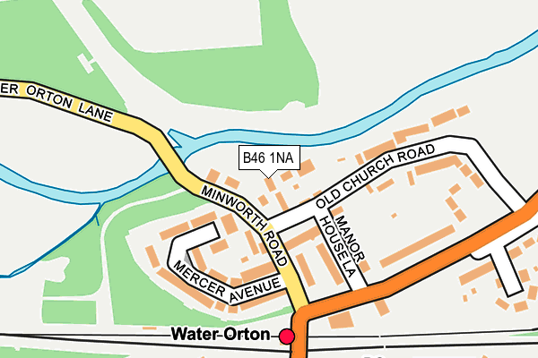
B46 1NA lies on Stonecross in Water Orton, Birmingham. B46 1NA is located in the Water Orton electoral ward, within the local authority district of North Warwickshire and the English Parliamentary constituency of North Warwickshire. The Sub Integrated Care Board (ICB) Location is NHS Coventry and Warwickshire ICB - B2M3M and the police force is Warwickshire. This postcode has been in use since March 1988.


GetTheData
Source: OS OpenMap – Local (Ordnance Survey)
Source: OS VectorMap District (Ordnance Survey)
Licence: Open Government Licence (requires attribution)
| Easting | 417517 |
| Northing | 291400 |
| Latitude | 52.520202 |
| Longitude | -1.743273 |
GetTheData
Source: Open Postcode Geo
Licence: Open Government Licence
| Street | Stonecross |
| Locality | Water Orton |
| Town/City | Birmingham |
| Country | England |
| Postcode District | B46 |
➜ See where B46 is on a map ➜ Where is Water Orton? | |
GetTheData
Source: Land Registry Price Paid Data
Licence: Open Government Licence
Elevation or altitude of B46 1NA as distance above sea level:
| Metres | Feet | |
|---|---|---|
| Elevation | 80m | 262ft |
Elevation is measured from the approximate centre of the postcode, to the nearest point on an OS contour line from OS Terrain 50, which has contour spacing of ten vertical metres.
➜ How high above sea level am I? Find the elevation of your current position using your device's GPS.
GetTheData
Source: Open Postcode Elevation
Licence: Open Government Licence
| Ward | Water Orton |
| Constituency | North Warwickshire |
GetTheData
Source: ONS Postcode Database
Licence: Open Government Licence
| Dog Inn (Marsh Lane) | Water Orton | 163m |
| Dog Inn (Marsh Lane) | Water Orton | 180m |
| Railway Station (Birmingham Road) | Water Orton | 229m |
| Railway Station (Birmingham Road) | Water Orton | 244m |
| Hargrave Close (New Road) | Water Orton | 361m |
| Water Orton Station | 0.2km |
| Coleshill Parkway Station | 2.4km |
| Lea Hall Station | 5.3km |
GetTheData
Source: NaPTAN
Licence: Open Government Licence
| Percentage of properties with Next Generation Access | 100.0% |
| Percentage of properties with Superfast Broadband | 100.0% |
| Percentage of properties with Ultrafast Broadband | 0.0% |
| Percentage of properties with Full Fibre Broadband | 0.0% |
Superfast Broadband is between 30Mbps and 300Mbps
Ultrafast Broadband is > 300Mbps
| Percentage of properties unable to receive 2Mbps | 0.0% |
| Percentage of properties unable to receive 5Mbps | 0.0% |
| Percentage of properties unable to receive 10Mbps | 0.0% |
| Percentage of properties unable to receive 30Mbps | 0.0% |
GetTheData
Source: Ofcom
Licence: Ofcom Terms of Use (requires attribution)
GetTheData
Source: ONS Postcode Database
Licence: Open Government Licence


➜ Get more ratings from the Food Standards Agency
GetTheData
Source: Food Standards Agency
Licence: FSA terms & conditions
| Last Collection | |||
|---|---|---|---|
| Location | Mon-Fri | Sat | Distance |
| Water Orton Post Office | 17:15 | 11:00 | 245m |
| Plank Lane / Bham Road | 17:15 | 11:00 | 527m |
| Water Orton School | 17:15 | 07:00 | 713m |
GetTheData
Source: Dracos
Licence: Creative Commons Attribution-ShareAlike
The below table lists the International Territorial Level (ITL) codes (formerly Nomenclature of Territorial Units for Statistics (NUTS) codes) and Local Administrative Units (LAU) codes for B46 1NA:
| ITL 1 Code | Name |
|---|---|
| TLG | West Midlands (England) |
| ITL 2 Code | Name |
| TLG1 | Herefordshire, Worcestershire and Warwickshire |
| ITL 3 Code | Name |
| TLG13 | Warwickshire CC |
| LAU 1 Code | Name |
| E07000218 | North Warwickshire |
GetTheData
Source: ONS Postcode Directory
Licence: Open Government Licence
The below table lists the Census Output Area (OA), Lower Layer Super Output Area (LSOA), and Middle Layer Super Output Area (MSOA) for B46 1NA:
| Code | Name | |
|---|---|---|
| OA | E00158252 | |
| LSOA | E01031042 | North Warwickshire 006F |
| MSOA | E02006473 | North Warwickshire 006 |
GetTheData
Source: ONS Postcode Directory
Licence: Open Government Licence
| B46 1NE | Manor House Way | 36m |
| B46 1NH | Minworth Road | 76m |
| B46 1NQ | Mercer Avenue | 89m |
| B46 1NF | Old Church Road | 107m |
| B46 1NL | Manor House Lane | 124m |
| B46 1NG | Mercer Avenue | 152m |
| B46 1NJ | Old Church Road | 167m |
| B46 1NN | Marsh Lane | 195m |
| B46 1SR | Birmingham Road | 225m |
| B46 1QS | Station Drive | 248m |
GetTheData
Source: Open Postcode Geo; Land Registry Price Paid Data
Licence: Open Government Licence