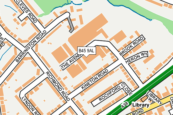
B45 9AL lies on The Avenue in Rubery, Birmingham. B45 9AL is located in the Rubery North electoral ward, within the local authority district of Bromsgrove and the English Parliamentary constituency of Bromsgrove. The Sub Integrated Care Board (ICB) Location is NHS Herefordshire and Worcestershire ICB - 18C and the police force is West Mercia. This postcode has been in use since January 1980.


GetTheData
Source: OS OpenMap – Local (Ordnance Survey)
Source: OS VectorMap District (Ordnance Survey)
Licence: Open Government Licence (requires attribution)
| Easting | 398361 |
| Northing | 277330 |
| Latitude | 52.394001 |
| Longitude | -2.025502 |
GetTheData
Source: Open Postcode Geo
Licence: Open Government Licence
| Street | The Avenue |
| Locality | Rubery |
| Town/City | Birmingham |
| Country | England |
| Postcode District | B45 |
➜ See where B45 is on a map ➜ Where is Birmingham? | |
GetTheData
Source: Land Registry Price Paid Data
Licence: Open Government Licence
Elevation or altitude of B45 9AL as distance above sea level:
| Metres | Feet | |
|---|---|---|
| Elevation | 200m | 656ft |
Elevation is measured from the approximate centre of the postcode, to the nearest point on an OS contour line from OS Terrain 50, which has contour spacing of ten vertical metres.
➜ How high above sea level am I? Find the elevation of your current position using your device's GPS.
GetTheData
Source: Open Postcode Elevation
Licence: Open Government Licence
| Ward | Rubery North |
| Constituency | Bromsgrove |
GetTheData
Source: ONS Postcode Database
Licence: Open Government Licence
51, THE AVENUE, RUBERY, BIRMINGHAM, B45 9AL 2021 7 APR £320,000 |
51, THE AVENUE, RUBERY, BIRMINGHAM, B45 9AL 2003 20 JUN £230,000 |
GetTheData
Source: HM Land Registry Price Paid Data
Licence: Contains HM Land Registry data © Crown copyright and database right 2025. This data is licensed under the Open Government Licence v3.0.
| Library Way (New Road) | Rubery | 260m |
| Gunner Lane (Barrington Rd) | Rubery | 282m |
| Rea Avenue (Windmill Avenue) | Rubery | 290m |
| Library Way (New Road) | Rubery | 297m |
| Rea Avenue (Windmill Avenue) | Rubery | 298m |
| Longbridge Station | 3km |
| Barnt Green Station | 4.3km |
| Northfield Station | 4.4km |
GetTheData
Source: NaPTAN
Licence: Open Government Licence
| Median download speed | 79.7Mbps |
| Average download speed | 59.0Mbps |
| Maximum download speed | 80.00Mbps |
| Median upload speed | 20.0Mbps |
| Average upload speed | 14.6Mbps |
| Maximum upload speed | 20.00Mbps |
GetTheData
Source: Ofcom
Licence: Ofcom Terms of Use (requires attribution)
GetTheData
Source: ONS Postcode Database
Licence: Open Government Licence


➜ Get more ratings from the Food Standards Agency
GetTheData
Source: Food Standards Agency
Licence: FSA terms & conditions
| Last Collection | |||
|---|---|---|---|
| Location | Mon-Fri | Sat | Distance |
| The Avenue / Brook Road | 17:45 | 11:30 | 98m |
| Rubery Post Office | 17:15 | 11:30 | 357m |
| Segborne Road Windmill Avenue | 17:45 | 11:45 | 388m |
GetTheData
Source: Dracos
Licence: Creative Commons Attribution-ShareAlike
The below table lists the International Territorial Level (ITL) codes (formerly Nomenclature of Territorial Units for Statistics (NUTS) codes) and Local Administrative Units (LAU) codes for B45 9AL:
| ITL 1 Code | Name |
|---|---|
| TLG | West Midlands (England) |
| ITL 2 Code | Name |
| TLG1 | Herefordshire, Worcestershire and Warwickshire |
| ITL 3 Code | Name |
| TLG12 | Worcestershire CC |
| LAU 1 Code | Name |
| E07000234 | Bromsgrove |
GetTheData
Source: ONS Postcode Directory
Licence: Open Government Licence
The below table lists the Census Output Area (OA), Lower Layer Super Output Area (LSOA), and Middle Layer Super Output Area (MSOA) for B45 9AL:
| Code | Name | |
|---|---|---|
| OA | E00164096 | |
| LSOA | E01032170 | Bromsgrove 003B |
| MSOA | E02006698 | Bromsgrove 003 |
GetTheData
Source: ONS Postcode Directory
Licence: Open Government Licence
| B45 9UJ | Kineton Road | 73m |
| B45 9UE | The Avenue | 130m |
| B45 9ES | Barrington Road | 131m |
| B45 9JX | Rochford Close | 133m |
| B45 9UH | Brook Road | 138m |
| B45 9UN | Richmond Road | 153m |
| B45 9EU | Barrington Road | 178m |
| B45 9UW | Richmond Road | 184m |
| B45 9HW | Callowbrook Lane | 186m |
| B45 9UL | Richmond Road | 188m |
GetTheData
Source: Open Postcode Geo; Land Registry Price Paid Data
Licence: Open Government Licence