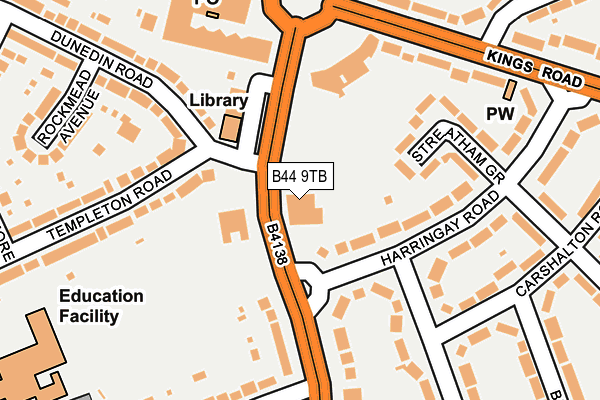
B44 9TB is located in the Kingstanding electoral ward, within the metropolitan district of Birmingham and the English Parliamentary constituency of Birmingham, Erdington. The Sub Integrated Care Board (ICB) Location is NHS Birmingham and Solihull ICB - 15E and the police force is West Midlands. This postcode has been in use since January 1980.


GetTheData
Source: OS OpenMap – Local (Ordnance Survey)
Source: OS VectorMap District (Ordnance Survey)
Licence: Open Government Licence (requires attribution)
| Easting | 407938 |
| Northing | 294818 |
| Latitude | 52.551166 |
| Longitude | -1.884356 |
GetTheData
Source: Open Postcode Geo
Licence: Open Government Licence
| Country | England |
| Postcode District | B44 |
➜ See where B44 is on a map ➜ Where is Birmingham? | |
GetTheData
Source: Land Registry Price Paid Data
Licence: Open Government Licence
Elevation or altitude of B44 9TB as distance above sea level:
| Metres | Feet | |
|---|---|---|
| Elevation | 140m | 459ft |
Elevation is measured from the approximate centre of the postcode, to the nearest point on an OS contour line from OS Terrain 50, which has contour spacing of ten vertical metres.
➜ How high above sea level am I? Find the elevation of your current position using your device's GPS.
GetTheData
Source: Open Postcode Elevation
Licence: Open Government Licence
| Ward | Kingstanding |
| Constituency | Birmingham, Erdington |
GetTheData
Source: ONS Postcode Database
Licence: Open Government Licence
| Kingstanding Library (Kingstanding Circle) | Kingstanding | 104m |
| Old Oscott Hill (Kingstanding Rd) | Kingstanding | 127m |
| Old Oscott Hill (Kingstanding Rd) | Kingstanding | 164m |
| Dental Health Centre (Kingstanding Circle) | Kingstanding | 172m |
| Kingstanding Circle Eastside (Kings Rd) | Kingstanding | 205m |
| Wylde Green Station | 3.6km |
| Hamstead (Birmingham) Station | 3.8km |
| Chester Road Station | 3.9km |
GetTheData
Source: NaPTAN
Licence: Open Government Licence
GetTheData
Source: ONS Postcode Database
Licence: Open Government Licence


➜ Get more ratings from the Food Standards Agency
GetTheData
Source: Food Standards Agency
Licence: FSA terms & conditions
| Last Collection | |||
|---|---|---|---|
| Location | Mon-Fri | Sat | Distance |
| Kingstanding Post Office | 17:30 | 12:30 | 242m |
| Colindale Road / Kings Road | 17:30 | 12:30 | 261m |
| Kingstanding Road | 17:15 | 12:30 | 437m |
GetTheData
Source: Dracos
Licence: Creative Commons Attribution-ShareAlike
The below table lists the International Territorial Level (ITL) codes (formerly Nomenclature of Territorial Units for Statistics (NUTS) codes) and Local Administrative Units (LAU) codes for B44 9TB:
| ITL 1 Code | Name |
|---|---|
| TLG | West Midlands (England) |
| ITL 2 Code | Name |
| TLG3 | West Midlands |
| ITL 3 Code | Name |
| TLG31 | Birmingham |
| LAU 1 Code | Name |
| E08000025 | Birmingham |
GetTheData
Source: ONS Postcode Directory
Licence: Open Government Licence
The below table lists the Census Output Area (OA), Lower Layer Super Output Area (LSOA), and Middle Layer Super Output Area (MSOA) for B44 9TB:
| Code | Name | |
|---|---|---|
| OA | E00046314 | |
| LSOA | E01009131 | Birmingham 011D |
| MSOA | E02001837 | Birmingham 011 |
GetTheData
Source: ONS Postcode Directory
Licence: Open Government Licence
| B44 0UB | Harringay Road | 97m |
| B44 0UA | Harringay Road | 111m |
| B44 9SS | Kingstanding Road | 128m |
| B44 9SU | Kingstanding Road | 132m |
| B44 0UD | Streatham Grove | 139m |
| B44 0NH | Hurlingham Road | 161m |
| B44 0TY | Harringay Road | 178m |
| B44 0UG | Kings Road | 202m |
| B44 9BT | Templeton Road | 203m |
| B44 9BU | Templeton Road | 205m |
GetTheData
Source: Open Postcode Geo; Land Registry Price Paid Data
Licence: Open Government Licence