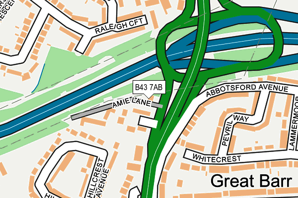
B43 7AB lies on Birmingham Road in Great Barr, Birmingham. B43 7AB is located in the Great Barr with Yew Tree electoral ward, within the metropolitan district of Sandwell and the English Parliamentary constituency of West Bromwich East. The Sub Integrated Care Board (ICB) Location is NHS Black Country ICB - D2P2L and the police force is West Midlands. This postcode has been in use since January 1980.


GetTheData
Source: OS OpenMap – Local (Ordnance Survey)
Source: OS VectorMap District (Ordnance Survey)
Licence: Open Government Licence (requires attribution)
| Easting | 404452 |
| Northing | 294904 |
| Latitude | 52.551979 |
| Longitude | -1.935767 |
GetTheData
Source: Open Postcode Geo
Licence: Open Government Licence
| Street | Birmingham Road |
| Locality | Great Barr |
| Town/City | Birmingham |
| Country | England |
| Postcode District | B43 |
➜ See where B43 is on a map ➜ Where is West Bromwich? | |
GetTheData
Source: Land Registry Price Paid Data
Licence: Open Government Licence
Elevation or altitude of B43 7AB as distance above sea level:
| Metres | Feet | |
|---|---|---|
| Elevation | 160m | 525ft |
Elevation is measured from the approximate centre of the postcode, to the nearest point on an OS contour line from OS Terrain 50, which has contour spacing of ten vertical metres.
➜ How high above sea level am I? Find the elevation of your current position using your device's GPS.
GetTheData
Source: Open Postcode Elevation
Licence: Open Government Licence
| Ward | Great Barr With Yew Tree |
| Constituency | West Bromwich East |
GetTheData
Source: ONS Postcode Database
Licence: Open Government Licence
2016 26 JUL £360,000 |
2006 3 NOV £300,000 |
2003 24 JUL £187,500 |
2001 20 AUG £264,000 |
1998 23 OCT £105,000 |
GetTheData
Source: HM Land Registry Price Paid Data
Licence: Contains HM Land Registry data © Crown copyright and database right 2025. This data is licensed under the Open Government Licence v3.0.
| Lochranza Croft (Birmingham Rd) | Gorse Farm | 11m |
| Scott Rd (Birmingham Rd) | Gorse Farm | 251m |
| The Post House (Birmingham Rd) | Gorse Farm | 295m |
| Scott Rd (Birmingham Rd) | Gorse Farm | 296m |
| Rokeby Rd | Gorse Farm | 396m |
| Hamstead (Birmingham) Station | 2.4km |
| Tame Bridge Parkway Station | 2.7km |
| Bescot Stadium Station | 4km |
GetTheData
Source: NaPTAN
Licence: Open Government Licence
GetTheData
Source: ONS Postcode Database
Licence: Open Government Licence


➜ Get more ratings from the Food Standards Agency
GetTheData
Source: Food Standards Agency
Licence: FSA terms & conditions
| Last Collection | |||
|---|---|---|---|
| Location | Mon-Fri | Sat | Distance |
| Barrhill Close / Birmingham Ro | 17:30 | 12:15 | 171m |
| Abbottsford Avenue / Lammermoo | 17:15 | 12:30 | 315m |
| Sycamore Road / Wilderness Lane | 17:30 | 12:15 | 505m |
GetTheData
Source: Dracos
Licence: Creative Commons Attribution-ShareAlike
The below table lists the International Territorial Level (ITL) codes (formerly Nomenclature of Territorial Units for Statistics (NUTS) codes) and Local Administrative Units (LAU) codes for B43 7AB:
| ITL 1 Code | Name |
|---|---|
| TLG | West Midlands (England) |
| ITL 2 Code | Name |
| TLG3 | West Midlands |
| ITL 3 Code | Name |
| TLG37 | Sandwell |
| LAU 1 Code | Name |
| E08000028 | Sandwell |
GetTheData
Source: ONS Postcode Directory
Licence: Open Government Licence
The below table lists the Census Output Area (OA), Lower Layer Super Output Area (LSOA), and Middle Layer Super Output Area (MSOA) for B43 7AB:
| Code | Name | |
|---|---|---|
| OA | E00050424 | |
| LSOA | E01009974 | Sandwell 006C |
| MSOA | E02002048 | Sandwell 006 |
GetTheData
Source: ONS Postcode Directory
Licence: Open Government Licence
| B43 7AA | Lochranza Croft | 57m |
| B43 7AF | Amie Lane | 114m |
| B43 6NT | Birmingham Road | 114m |
| B43 6EP | Whitecrest | 126m |
| B43 6HD | Abbotsford Avenue | 127m |
| B43 7SN | Raleigh Croft | 144m |
| B43 7SP | Sycamore Road | 155m |
| B43 7SR | Waltdene Close | 156m |
| B43 6NU | Birmingham Road | 160m |
| B43 6LX | Hillcrest Avenue | 167m |
GetTheData
Source: Open Postcode Geo; Land Registry Price Paid Data
Licence: Open Government Licence