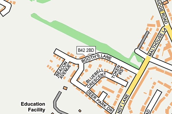
B42 2BD is located in the Oscott electoral ward, within the metropolitan district of Birmingham and the English Parliamentary constituency of Birmingham, Perry Barr. The Sub Integrated Care Board (ICB) Location is NHS Birmingham and Solihull ICB - 15E and the police force is West Midlands. This postcode has been in use since April 2017.


GetTheData
Source: OS OpenMap – Local (Ordnance Survey)
Source: OS VectorMap District (Ordnance Survey)
Licence: Open Government Licence (requires attribution)
| Easting | 406280 |
| Northing | 293949 |
| Latitude | 52.543376 |
| Longitude | -1.908825 |
GetTheData
Source: Open Postcode Geo
Licence: Open Government Licence
| Country | England |
| Postcode District | B42 |
➜ See where B42 is on a map ➜ Where is Birmingham? | |
GetTheData
Source: Land Registry Price Paid Data
Licence: Open Government Licence
| Ward | Oscott |
| Constituency | Birmingham, Perry Barr |
GetTheData
Source: ONS Postcode Database
Licence: Open Government Licence
2021 9 DEC £370,000 |
2021 30 JUN £312,500 |
184, BOOTHS LANE, BIRMINGHAM, B42 2BD 2019 15 AUG £313,950 |
180, BOOTHS LANE, BIRMINGHAM, B42 2BD 2019 2 AUG £316,950 |
182, BOOTHS LANE, BIRMINGHAM, B42 2BD 2019 19 JUL £244,950 |
2019 21 JUN £205,000 |
200, BOOTHS LANE, BIRMINGHAM, B42 2BD 2018 16 NOV £244,950 |
202, BOOTHS LANE, BIRMINGHAM, B42 2BD 2018 2 NOV £240,500 |
204, BOOTHS LANE, BIRMINGHAM, B42 2BD 2018 30 OCT £302,950 |
206, BOOTHS LANE, BIRMINGHAM, B42 2BD 2018 7 SEP £306,950 |
GetTheData
Source: HM Land Registry Price Paid Data
Licence: Contains HM Land Registry data © Crown copyright and database right 2024. This data is licensed under the Open Government Licence v3.0.
| Dyas Rd (Aldridge Rd) | Old Oscott | 412m |
| Dyas Rd (Aldridge Rd) | Old Oscott | 436m |
| Perry Beeches School (Beeches Rd) | Perry Beeches | 443m |
| Perry Beeches School (Beeches Rd) | Perry Beeches | 448m |
| Great Barr School (Aldridge Rd) | Old Oscott | 453m |
| Hamstead (Birmingham) Station | 1.9km |
| Perry Barr Station | 3km |
| Witton (West Midlands) Station | 3.8km |
GetTheData
Source: NaPTAN
Licence: Open Government Licence
| Percentage of properties with Next Generation Access | 50.0% |
| Percentage of properties with Superfast Broadband | 50.0% |
| Percentage of properties with Ultrafast Broadband | 50.0% |
| Percentage of properties with Full Fibre Broadband | 50.0% |
Superfast Broadband is between 30Mbps and 300Mbps
Ultrafast Broadband is > 300Mbps
| Median download speed | 10.9Mbps |
| Average download speed | 9.8Mbps |
| Maximum download speed | 15.35Mbps |
| Median upload speed | 1.0Mbps |
| Average upload speed | 1.0Mbps |
| Maximum upload speed | 1.25Mbps |
| Percentage of properties unable to receive 2Mbps | 0.0% |
| Percentage of properties unable to receive 5Mbps | 0.0% |
| Percentage of properties unable to receive 10Mbps | 0.0% |
| Percentage of properties unable to receive 30Mbps | 50.0% |
GetTheData
Source: Ofcom
Licence: Ofcom Terms of Use (requires attribution)
GetTheData
Source: ONS Postcode Database
Licence: Open Government Licence


➜ Get more ratings from the Food Standards Agency
GetTheData
Source: Food Standards Agency
Licence: FSA terms & conditions
| Last Collection | |||
|---|---|---|---|
| Location | Mon-Fri | Sat | Distance |
| Perry Beeches Post Office | 17:15 | 12:30 | 409m |
| Booths Lane / Bowman Road | 17:15 | 12:30 | 540m |
| 91 Turnberry Road | 17:30 | 12:30 | 557m |
GetTheData
Source: Dracos
Licence: Creative Commons Attribution-ShareAlike
The below table lists the International Territorial Level (ITL) codes (formerly Nomenclature of Territorial Units for Statistics (NUTS) codes) and Local Administrative Units (LAU) codes for B42 2BD:
| ITL 1 Code | Name |
|---|---|
| TLG | West Midlands (England) |
| ITL 2 Code | Name |
| TLG3 | West Midlands |
| ITL 3 Code | Name |
| TLG31 | Birmingham |
| LAU 1 Code | Name |
| E08000025 | Birmingham |
GetTheData
Source: ONS Postcode Directory
Licence: Open Government Licence
The below table lists the Census Output Area (OA), Lower Layer Super Output Area (LSOA), and Middle Layer Super Output Area (MSOA) for B42 2BD:
| Code | Name | |
|---|---|---|
| OA | E00046836 | |
| LSOA | E01009243 | Birmingham 016B |
| MSOA | E02001842 | Birmingham 016 |
GetTheData
Source: ONS Postcode Directory
Licence: Open Government Licence
| B42 2BW | Deer Park Drive | 202m |
| B42 2DY | Booths Farm Close | 218m |
| B42 2FS | Bluebell Crescent | 227m |
| B42 2FR | Queslett Way | 243m |
| B42 2JU | Booths Lane | 307m |
| B42 2RL | Caddick Road | 327m |
| B42 2JY | Fairyfield Croft | 332m |
| B42 2RJ | Caddick Road | 335m |
| B42 2JX | Malthouse Lane | 351m |
| B42 2QG | Sandy Lane | 358m |
GetTheData
Source: Open Postcode Geo; Land Registry Price Paid Data
Licence: Open Government Licence