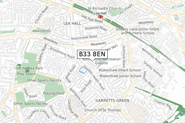
B33 8EN is located in the Garretts Green electoral ward, within the metropolitan district of Birmingham and the English Parliamentary constituency of Birmingham, Yardley. The Sub Integrated Care Board (ICB) Location is NHS Birmingham and Solihull ICB - 15E and the police force is West Midlands. This postcode has been in use since December 2018.


GetTheData
Source: OS Open Zoomstack (Ordnance Survey)
Licence: Open Government Licence (requires attribution)
Attribution: Contains OS data © Crown copyright and database right 2025
Source: Open Postcode Geo
Licence: Open Government Licence (requires attribution)
Attribution: Contains OS data © Crown copyright and database right 2025; Contains Royal Mail data © Royal Mail copyright and database right 2025; Source: Office for National Statistics licensed under the Open Government Licence v.3.0
| Easting | 414496 |
| Northing | 286387 |
| Latitude | 52.475238 |
| Longitude | -1.788005 |
GetTheData
Source: Open Postcode Geo
Licence: Open Government Licence
| Country | England |
| Postcode District | B33 |
➜ See where B33 is on a map ➜ Where is Birmingham? | |
GetTheData
Source: Land Registry Price Paid Data
Licence: Open Government Licence
| Ward | Garretts Green |
| Constituency | Birmingham, Yardley |
GetTheData
Source: ONS Postcode Database
Licence: Open Government Licence
2024 28 MAR £350,000 |
2018 14 DEC £259,995 |
GetTheData
Source: HM Land Registry Price Paid Data
Licence: Contains HM Land Registry data © Crown copyright and database right 2025. This data is licensed under the Open Government Licence v3.0.
| Kents Moat (Sheldon Heath Rd) | Garretts Green | 106m |
| Kents Moat (Sheldon Heath Rd) | Garretts Green | 124m |
| Poolway Shopping Centre (Meadway) | Lea Hall | 221m |
| Holbeach Rd (Meadway) | Lea Hall | 238m |
| Poolway Shopping Centre (Meadway) | Lea Hall | 264m |
| Lea Hall Station | 0.6km |
| Stechford Station | 1.9km |
| Marston Green Station | 2.4km |
GetTheData
Source: NaPTAN
Licence: Open Government Licence
| Percentage of properties with Next Generation Access | 100.0% |
| Percentage of properties with Superfast Broadband | 100.0% |
| Percentage of properties with Ultrafast Broadband | 92.3% |
| Percentage of properties with Full Fibre Broadband | 92.3% |
Superfast Broadband is between 30Mbps and 300Mbps
Ultrafast Broadband is > 300Mbps
| Percentage of properties unable to receive 2Mbps | 0.0% |
| Percentage of properties unable to receive 5Mbps | 0.0% |
| Percentage of properties unable to receive 10Mbps | 0.0% |
| Percentage of properties unable to receive 30Mbps | 0.0% |
GetTheData
Source: Ofcom
Licence: Ofcom Terms of Use (requires attribution)
GetTheData
Source: ONS Postcode Database
Licence: Open Government Licence


➜ Get more ratings from the Food Standards Agency
GetTheData
Source: Food Standards Agency
Licence: FSA terms & conditions
| Last Collection | |||
|---|---|---|---|
| Location | Mon-Fri | Sat | Distance |
| Meadway Post Office | 17:30 | 11:30 | 222m |
| Broadstone Road | 17:15 | 11:30 | 343m |
| Brinsley Road | 17:30 | 11:30 | 636m |
GetTheData
Source: Dracos
Licence: Creative Commons Attribution-ShareAlike
The below table lists the International Territorial Level (ITL) codes (formerly Nomenclature of Territorial Units for Statistics (NUTS) codes) and Local Administrative Units (LAU) codes for B33 8EN:
| ITL 1 Code | Name |
|---|---|
| TLG | West Midlands (England) |
| ITL 2 Code | Name |
| TLG3 | West Midlands |
| ITL 3 Code | Name |
| TLG31 | Birmingham |
| LAU 1 Code | Name |
| E08000025 | Birmingham |
GetTheData
Source: ONS Postcode Directory
Licence: Open Government Licence
The below table lists the Census Output Area (OA), Lower Layer Super Output Area (LSOA), and Middle Layer Super Output Area (MSOA) for B33 8EN:
| Code | Name | |
|---|---|---|
| OA | E00175795 | |
| LSOA | E01009514 | Birmingham 062B |
| MSOA | E02001888 | Birmingham 062 |
GetTheData
Source: ONS Postcode Directory
Licence: Open Government Licence
| B26 2DJ | Sheldon Heath Road | 134m |
| B26 2DH | Sheldon Heath Road | 140m |
| B26 2DN | Fleetwood Grove | 186m |
| B33 8NF | Pool Way | 189m |
| B33 8ND | Pool Way | 190m |
| B33 0XA | Blakenhale Road | 228m |
| B26 2DL | The Hays Kents Moat | 242m |
| B26 2ES | Este Road | 250m |
| B26 2EW | Hengham Road | 265m |
| B26 2DQ | Sheldon Heath Road | 266m |
GetTheData
Source: Open Postcode Geo; Land Registry Price Paid Data
Licence: Open Government Licence