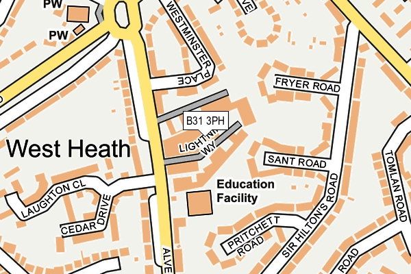
B31 3PH is located in the Longbridge & West Heath electoral ward, within the metropolitan district of Birmingham and the English Parliamentary constituency of Birmingham, Northfield. The Sub Integrated Care Board (ICB) Location is NHS Birmingham and Solihull ICB - 15E and the police force is West Midlands. This postcode has been in use since January 1980.


GetTheData
Source: OS OpenMap – Local (Ordnance Survey)
Source: OS VectorMap District (Ordnance Survey)
Licence: Open Government Licence (requires attribution)
| Easting | 402843 |
| Northing | 277389 |
| Latitude | 52.394514 |
| Longitude | -1.959646 |
GetTheData
Source: Open Postcode Geo
Licence: Open Government Licence
| Country | England |
| Postcode District | B31 |
➜ See where B31 is on a map ➜ Where is Birmingham? | |
GetTheData
Source: Land Registry Price Paid Data
Licence: Open Government Licence
Elevation or altitude of B31 3PH as distance above sea level:
| Metres | Feet | |
|---|---|---|
| Elevation | 180m | 591ft |
Elevation is measured from the approximate centre of the postcode, to the nearest point on an OS contour line from OS Terrain 50, which has contour spacing of ten vertical metres.
➜ How high above sea level am I? Find the elevation of your current position using your device's GPS.
GetTheData
Source: Open Postcode Elevation
Licence: Open Government Licence
| Ward | Longbridge & West Heath |
| Constituency | Birmingham, Northfield |
GetTheData
Source: ONS Postcode Database
Licence: Open Government Licence
| West Heath Island (Lilley Lane) | West Heath | 234m |
| West Heath Church (Cofton Rd) | West Heath | 238m |
| West Heath Church (Cofton Rd) | West Heath | 240m |
| West Heath Island (Lilley Lane) | West Heath | 245m |
| West Heath Island (Cropredy Rd) | West Heath | 278m |
| Longbridge Station | 1.5km |
| Northfield Station | 1.6km |
| Kings Norton Station | 2.9km |
GetTheData
Source: NaPTAN
Licence: Open Government Licence
GetTheData
Source: ONS Postcode Database
Licence: Open Government Licence


➜ Get more ratings from the Food Standards Agency
GetTheData
Source: Food Standards Agency
Licence: FSA terms & conditions
| Last Collection | |||
|---|---|---|---|
| Location | Mon-Fri | Sat | Distance |
| 51 Sir Hiltons Road | 17:30 | 12:30 | 194m |
| Alvechurch Road / Sir Hiltons | 17:30 | 12:30 | 327m |
| Redditch Road / Redhill Road | 17:30 | 12:30 | 396m |
GetTheData
Source: Dracos
Licence: Creative Commons Attribution-ShareAlike
The below table lists the International Territorial Level (ITL) codes (formerly Nomenclature of Territorial Units for Statistics (NUTS) codes) and Local Administrative Units (LAU) codes for B31 3PH:
| ITL 1 Code | Name |
|---|---|
| TLG | West Midlands (England) |
| ITL 2 Code | Name |
| TLG3 | West Midlands |
| ITL 3 Code | Name |
| TLG31 | Birmingham |
| LAU 1 Code | Name |
| E08000025 | Birmingham |
GetTheData
Source: ONS Postcode Directory
Licence: Open Government Licence
The below table lists the Census Output Area (OA), Lower Layer Super Output Area (LSOA), and Middle Layer Super Output Area (MSOA) for B31 3PH:
| Code | Name | |
|---|---|---|
| OA | E00046719 | |
| LSOA | E01009217 | Birmingham 131E |
| MSOA | E02001957 | Birmingham 131 |
GetTheData
Source: ONS Postcode Directory
Licence: Open Government Licence
| B31 3PN | Alvechurch Road | 79m |
| B31 3PW | Alvechurch Road | 107m |
| B31 3NJ | Sant Road | 110m |
| B31 3PL | Westminster Place | 112m |
| B31 3NL | Pritchett Road | 136m |
| B31 3NG | Fryer Road | 157m |
| B31 3NH | Sir Hiltons Road | 167m |
| B31 3JZ | Grove Mews | 183m |
| B31 3JX | The Grove | 186m |
| B31 3PE | Cedar Drive | 199m |
GetTheData
Source: Open Postcode Geo; Land Registry Price Paid Data
Licence: Open Government Licence