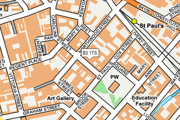
B3 1TS is located in the Soho & Jewellery Quarter electoral ward, within the metropolitan district of Birmingham and the English Parliamentary constituency of Birmingham, Ladywood. The Sub Integrated Care Board (ICB) Location is NHS Birmingham and Solihull ICB - 15E and the police force is West Midlands. This postcode has been in use since December 2016.


GetTheData
Source: OS OpenMap – Local (Ordnance Survey)
Source: OS VectorMap District (Ordnance Survey)
Licence: Open Government Licence (requires attribution)
| Easting | 406416 |
| Northing | 287571 |
| Latitude | 52.486036 |
| Longitude | -1.906941 |
GetTheData
Source: Open Postcode Geo
Licence: Open Government Licence
| Country | England |
| Postcode District | B3 |
➜ See where B3 is on a map ➜ Where is Birmingham? | |
GetTheData
Source: Land Registry Price Paid Data
Licence: Open Government Licence
Elevation or altitude of B3 1TS as distance above sea level:
| Metres | Feet | |
|---|---|---|
| Elevation | 130m | 427ft |
Elevation is measured from the approximate centre of the postcode, to the nearest point on an OS contour line from OS Terrain 50, which has contour spacing of ten vertical metres.
➜ How high above sea level am I? Find the elevation of your current position using your device's GPS.
GetTheData
Source: Open Postcode Elevation
Licence: Open Government Licence
| Ward | Soho & Jewellery Quarter |
| Constituency | Birmingham, Ladywood |
GetTheData
Source: ONS Postcode Database
Licence: Open Government Licence
| Vittoria St (Graham St) | Jewellery Quarter | 190m |
| Charlotte St (Newhall St) | International Convention Centre | 215m |
| St Paul`s Metro Stop (Constitution Hill) | Jewellery Quarter | 244m |
| Vittoria St (Graham St) | Jewellery Quarter | 247m |
| St Paul`s Metro Stop (Constitution Hill) | Jewellery Quarter | 261m |
| St Paul's (Midland Metro Stop) (Livery Street) | Jewellery Quarter | 217m |
| Jewellery Quarter (Midland Metro Stop) (Vyse St Hockley) | Jewellery Quarter | 586m |
| Snow Hill (Midland Metro Stop) (Colmore Row) | Birmingham | 594m |
| Bull Street (Midland Metro Stop) (Bull Street) | Birmingham | 857m |
| Corporation Street (Midland Metro Stop) (Corporation Street) | Birmingham | 955m |
| Jewellery Quarter Station | 0.6km |
| Birmingham Snow Hill Station | 0.6km |
| Birmingham New Street Station | 1km |
GetTheData
Source: NaPTAN
Licence: Open Government Licence
| Percentage of properties with Next Generation Access | 100.0% |
| Percentage of properties with Superfast Broadband | 100.0% |
| Percentage of properties with Ultrafast Broadband | 100.0% |
| Percentage of properties with Full Fibre Broadband | 100.0% |
Superfast Broadband is between 30Mbps and 300Mbps
Ultrafast Broadband is > 300Mbps
| Percentage of properties unable to receive 2Mbps | 0.0% |
| Percentage of properties unable to receive 5Mbps | 0.0% |
| Percentage of properties unable to receive 10Mbps | 0.0% |
| Percentage of properties unable to receive 30Mbps | 0.0% |
GetTheData
Source: Ofcom
Licence: Ofcom Terms of Use (requires attribution)
GetTheData
Source: ONS Postcode Database
Licence: Open Government Licence


➜ Get more ratings from the Food Standards Agency
GetTheData
Source: Food Standards Agency
Licence: FSA terms & conditions
| Last Collection | |||
|---|---|---|---|
| Location | Mon-Fri | Sat | Distance |
| Caroline St / Northwood St | 18:30 | 12:30 | 36m |
| Graham St | 18:30 | 12:30 | 182m |
| Newhall St / Charlotte St | 18:30 | 12:30 | 256m |
GetTheData
Source: Dracos
Licence: Creative Commons Attribution-ShareAlike
The below table lists the International Territorial Level (ITL) codes (formerly Nomenclature of Territorial Units for Statistics (NUTS) codes) and Local Administrative Units (LAU) codes for B3 1TS:
| ITL 1 Code | Name |
|---|---|
| TLG | West Midlands (England) |
| ITL 2 Code | Name |
| TLG3 | West Midlands |
| ITL 3 Code | Name |
| TLG31 | Birmingham |
| LAU 1 Code | Name |
| E08000025 | Birmingham |
GetTheData
Source: ONS Postcode Directory
Licence: Open Government Licence
The below table lists the Census Output Area (OA), Lower Layer Super Output Area (LSOA), and Middle Layer Super Output Area (MSOA) for B3 1TS:
| Code | Name | |
|---|---|---|
| OA | E00175708 | |
| LSOA | E01033623 | Birmingham 138C |
| MSOA | E02006899 | Birmingham 138 |
GetTheData
Source: ONS Postcode Directory
Licence: Open Government Licence
| B3 1TR | Caroline Street | 15m |
| B3 1UP | Caroline Street | 43m |
| B3 1QX | St Pauls Square | 57m |
| B3 1RW | Cox Street | 73m |
| B3 1FQ | St Pauls Square | 92m |
| B3 1TX | Northwood Street | 113m |
| B3 1SD | James Street | 117m |
| B3 1UD | Mary Street | 124m |
| B3 1RD | Cox Street | 124m |
| B3 1UQ | Caroline Street | 145m |
GetTheData
Source: Open Postcode Geo; Land Registry Price Paid Data
Licence: Open Government Licence