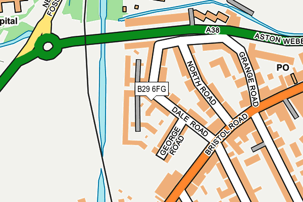
B29 6FG is located in the Bournbrook & Selly Park electoral ward, within the metropolitan district of Birmingham and the English Parliamentary constituency of Birmingham, Selly Oak. The Sub Integrated Care Board (ICB) Location is NHS Birmingham and Solihull ICB - 15E and the police force is West Midlands. This postcode has been in use since April 2003.


GetTheData
Source: OS OpenMap – Local (Ordnance Survey)
Source: OS VectorMap District (Ordnance Survey)
Licence: Open Government Licence (requires attribution)
| Easting | 404440 |
| Northing | 283109 |
| Latitude | 52.445927 |
| Longitude | -1.936103 |
GetTheData
Source: Open Postcode Geo
Licence: Open Government Licence
| Country | England |
| Postcode District | B29 |
➜ See where B29 is on a map ➜ Where is Birmingham? | |
GetTheData
Source: Land Registry Price Paid Data
Licence: Open Government Licence
Elevation or altitude of B29 6FG as distance above sea level:
| Metres | Feet | |
|---|---|---|
| Elevation | 130m | 427ft |
Elevation is measured from the approximate centre of the postcode, to the nearest point on an OS contour line from OS Terrain 50, which has contour spacing of ten vertical metres.
➜ How high above sea level am I? Find the elevation of your current position using your device's GPS.
GetTheData
Source: Open Postcode Elevation
Licence: Open Government Licence
| Ward | Bournbrook & Selly Park |
| Constituency | Birmingham, Selly Oak |
GetTheData
Source: ONS Postcode Database
Licence: Open Government Licence
| Hubert Rd (Bristol Rd) | Bournbrook | 145m |
| Dawlish Rd (Bristol Rd) | Bournbrook | 164m |
| Dawlish Rd (Bristol Rd) | Bournbrook | 174m |
| Hubert Rd (Bristol Rd) | Bournbrook | 175m |
| Hubert Rd (Bristol Rd) | Bournbrook | 183m |
| Selly Oak Station | 0.4km |
| University Station | 0.6km |
| Bournville Station | 2.2km |
GetTheData
Source: NaPTAN
Licence: Open Government Licence
GetTheData
Source: ONS Postcode Database
Licence: Open Government Licence


➜ Get more ratings from the Food Standards Agency
GetTheData
Source: Food Standards Agency
Licence: FSA terms & conditions
| Last Collection | |||
|---|---|---|---|
| Location | Mon-Fri | Sat | Distance |
| Tiverton Road / Bristol Road | 17:45 | 12:30 | 160m |
| Bournbrook Post Office | 17:45 | 12:30 | 269m |
| Exeter Road / Hubert Road | 17:45 | 12:30 | 556m |
GetTheData
Source: Dracos
Licence: Creative Commons Attribution-ShareAlike
The below table lists the International Territorial Level (ITL) codes (formerly Nomenclature of Territorial Units for Statistics (NUTS) codes) and Local Administrative Units (LAU) codes for B29 6FG:
| ITL 1 Code | Name |
|---|---|
| TLG | West Midlands (England) |
| ITL 2 Code | Name |
| TLG3 | West Midlands |
| ITL 3 Code | Name |
| TLG31 | Birmingham |
| LAU 1 Code | Name |
| E08000025 | Birmingham |
GetTheData
Source: ONS Postcode Directory
Licence: Open Government Licence
The below table lists the Census Output Area (OA), Lower Layer Super Output Area (LSOA), and Middle Layer Super Output Area (MSOA) for B29 6FG:
| Code | Name | |
|---|---|---|
| OA | E00175800 | |
| LSOA | E01009284 | Birmingham 096A |
| MSOA | E02001922 | Birmingham 096 |
GetTheData
Source: ONS Postcode Directory
Licence: Open Government Licence
| B29 6AG | Dale Road | 36m |
| B29 6AH | George Road | 74m |
| B29 6AN | North Road | 84m |
| B29 6AQ | Dale Road | 86m |
| B29 6AW | North Road | 111m |
| B29 6BQ | Bristol Road | 169m |
| B29 6BE | Bristol Road | 181m |
| B29 6AE | Bristol Road | 203m |
| B29 6AP | Grange Road | 216m |
| B29 6BJ | Bristol Road | 252m |
GetTheData
Source: Open Postcode Geo; Land Registry Price Paid Data
Licence: Open Government Licence