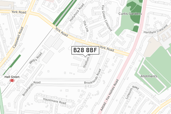
B28 8BF is located in the Hall Green North electoral ward, within the metropolitan district of Birmingham and the English Parliamentary constituency of Birmingham, Hall Green. The Sub Integrated Care Board (ICB) Location is NHS Birmingham and Solihull ICB - 15E and the police force is West Midlands. This postcode has been in use since June 2019.


GetTheData
Source: OS Open Zoomstack (Ordnance Survey)
Licence: Open Government Licence (requires attribution)
Attribution: Contains OS data © Crown copyright and database right 2025
Source: Open Postcode Geo
Licence: Open Government Licence (requires attribution)
Attribution: Contains OS data © Crown copyright and database right 2025; Contains Royal Mail data © Royal Mail copyright and database right 2025; Source: Office for National Statistics licensed under the Open Government Licence v.3.0
| Easting | 411013 |
| Northing | 282233 |
| Latitude | 52.437975 |
| Longitude | -1.839419 |
GetTheData
Source: Open Postcode Geo
Licence: Open Government Licence
| Country | England |
| Postcode District | B28 |
➜ See where B28 is on a map ➜ Where is Birmingham? | |
GetTheData
Source: Land Registry Price Paid Data
Licence: Open Government Licence
| Ward | Hall Green North |
| Constituency | Birmingham, Hall Green |
GetTheData
Source: ONS Postcode Database
Licence: Open Government Licence
76, STADIUM ROAD, BIRMINGHAM, B28 8BF 2024 19 AUG £285,000 |
58, STADIUM ROAD, BIRMINGHAM, B28 8BF 2020 22 DEC £350,000 |
106, STADIUM ROAD, BIRMINGHAM, B28 8BF 2019 23 AUG £340,000 |
GetTheData
Source: HM Land Registry Price Paid Data
Licence: Contains HM Land Registry data © Crown copyright and database right 2025. This data is licensed under the Open Government Licence v3.0.
| York Rd (Fox Hollies Rd) | Fox Hollies | 241m |
| Fox Hollies Surgery (Fox Hollies Rd) | Hall Green | 257m |
| York Rd (Fox Hollies Rd) | Fox Hollies | 303m |
| Fox Hollies Surgery (Fox Hollies Rd) | Hall Green | 310m |
| Hall Green Church (School Rd) | Hall Green | 400m |
| Hall Green Station | 0.4km |
| Spring Road Station | 0.6km |
| Tyseley Station | 1.8km |
GetTheData
Source: NaPTAN
Licence: Open Government Licence
| Percentage of properties with Next Generation Access | 0.0% |
| Percentage of properties with Superfast Broadband | 0.0% |
| Percentage of properties with Ultrafast Broadband | 0.0% |
| Percentage of properties with Full Fibre Broadband | 0.0% |
Superfast Broadband is between 30Mbps and 300Mbps
Ultrafast Broadband is > 300Mbps
| Percentage of properties unable to receive 2Mbps | 0.0% |
| Percentage of properties unable to receive 5Mbps | 0.0% |
| Percentage of properties unable to receive 10Mbps | 0.0% |
| Percentage of properties unable to receive 30Mbps | 0.0% |
GetTheData
Source: Ofcom
Licence: Ofcom Terms of Use (requires attribution)
GetTheData
Source: ONS Postcode Database
Licence: Open Government Licence


➜ Get more ratings from the Food Standards Agency
GetTheData
Source: Food Standards Agency
Licence: FSA terms & conditions
| Last Collection | |||
|---|---|---|---|
| Location | Mon-Fri | Sat | Distance |
| Fox Hollies Road York Road | 17:15 | 11:30 | 303m |
| Hollyhock Road / Fox Green Cre | 17:30 | 11:30 | 365m |
| Arcot Road / Cateswell Road | 17:30 | 11:30 | 469m |
GetTheData
Source: Dracos
Licence: Creative Commons Attribution-ShareAlike
The below table lists the International Territorial Level (ITL) codes (formerly Nomenclature of Territorial Units for Statistics (NUTS) codes) and Local Administrative Units (LAU) codes for B28 8BF:
| ITL 1 Code | Name |
|---|---|
| TLG | West Midlands (England) |
| ITL 2 Code | Name |
| TLG3 | West Midlands |
| ITL 3 Code | Name |
| TLG31 | Birmingham |
| LAU 1 Code | Name |
| E08000025 | Birmingham |
GetTheData
Source: ONS Postcode Directory
Licence: Open Government Licence
The below table lists the Census Output Area (OA), Lower Layer Super Output Area (LSOA), and Middle Layer Super Output Area (MSOA) for B28 8BF:
| Code | Name | |
|---|---|---|
| OA | E00045852 | |
| LSOA | E01009030 | Birmingham 098D |
| MSOA | E02001924 | Birmingham 098 |
GetTheData
Source: ONS Postcode Directory
Licence: Open Government Licence
| B28 8LA | Brooklands Road | 89m |
| B28 8LD | Brooklands Road | 125m |
| B28 8LF | York Road | 139m |
| B27 7SR | The Link | 162m |
| B28 8LB | Brooklands Road | 163m |
| B28 8LH | York Road | 174m |
| B28 8JZ | Brooklands Road | 185m |
| B27 7SN | Grimshaw Road | 188m |
| B27 7SS | The Link | 191m |
| B28 8RJ | Fox Hollies Road | 195m |
GetTheData
Source: Open Postcode Geo; Land Registry Price Paid Data
Licence: Open Government Licence