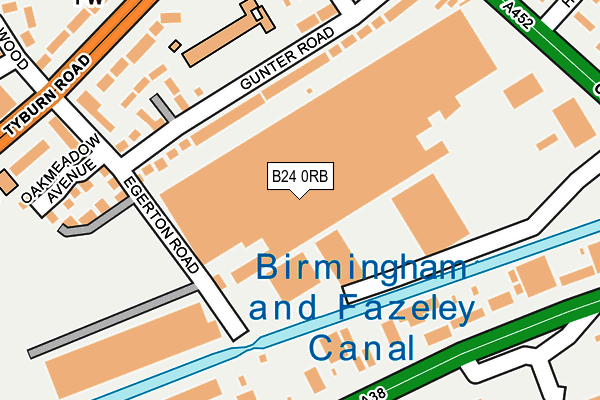
B24 0RB is located in the Pype Hayes electoral ward, within the metropolitan district of Birmingham and the English Parliamentary constituency of Birmingham, Erdington. The Sub Integrated Care Board (ICB) Location is NHS Birmingham and Solihull ICB - 15E and the police force is West Midlands. This postcode has been in use since January 1980.


GetTheData
Source: OS OpenMap – Local (Ordnance Survey)
Source: OS VectorMap District (Ordnance Survey)
Licence: Open Government Licence (requires attribution)
| Easting | 413175 |
| Northing | 291324 |
| Latitude | 52.519640 |
| Longitude | -1.807265 |
GetTheData
Source: Open Postcode Geo
Licence: Open Government Licence
| Country | England |
| Postcode District | B24 |
➜ See where B24 is on a map ➜ Where is Birmingham? | |
GetTheData
Source: Land Registry Price Paid Data
Licence: Open Government Licence
Elevation or altitude of B24 0RB as distance above sea level:
| Metres | Feet | |
|---|---|---|
| Elevation | 90m | 295ft |
Elevation is measured from the approximate centre of the postcode, to the nearest point on an OS contour line from OS Terrain 50, which has contour spacing of ten vertical metres.
➜ How high above sea level am I? Find the elevation of your current position using your device's GPS.
GetTheData
Source: Open Postcode Elevation
Licence: Open Government Licence
| Ward | Pype Hayes |
| Constituency | Birmingham, Erdington |
GetTheData
Source: ONS Postcode Database
Licence: Open Government Licence
| Ravenside Retail Park (Kingsbury Rd) | Tyburn | 231m |
| Egerton Rd (Tyburn Rd) | Pype Hayes | 266m |
| Egerton Rd (Tyburn Rd) | Pype Hayes | 274m |
| Ravenside Retail Park (Kingsbury Rd) | Tyburn | 287m |
| The Bagot Arms (Tyburn Rd) | Pype Hayes | 288m |
| Erdington Station | 2.4km |
| Chester Road Station | 2.5km |
| Gravelly Hill Station | 3.1km |
GetTheData
Source: NaPTAN
Licence: Open Government Licence
GetTheData
Source: ONS Postcode Database
Licence: Open Government Licence


➜ Get more ratings from the Food Standards Agency
GetTheData
Source: Food Standards Agency
Licence: FSA terms & conditions
| Last Collection | |||
|---|---|---|---|
| Location | Mon-Fri | Sat | Distance |
| Tyburn Post Office | 17:30 | 12:15 | 333m |
| Sorrel House / Tyburn Road | 16:45 | 12:30 | 351m |
| Varley Road / Edinburgh Close | 17:30 | 12:30 | 446m |
GetTheData
Source: Dracos
Licence: Creative Commons Attribution-ShareAlike
The below table lists the International Territorial Level (ITL) codes (formerly Nomenclature of Territorial Units for Statistics (NUTS) codes) and Local Administrative Units (LAU) codes for B24 0RB:
| ITL 1 Code | Name |
|---|---|
| TLG | West Midlands (England) |
| ITL 2 Code | Name |
| TLG3 | West Midlands |
| ITL 3 Code | Name |
| TLG31 | Birmingham |
| LAU 1 Code | Name |
| E08000025 | Birmingham |
GetTheData
Source: ONS Postcode Directory
Licence: Open Government Licence
The below table lists the Census Output Area (OA), Lower Layer Super Output Area (LSOA), and Middle Layer Super Output Area (MSOA) for B24 0RB:
| Code | Name | |
|---|---|---|
| OA | E00046153 | |
| LSOA | E01009098 | Birmingham 025C |
| MSOA | E02001851 | Birmingham 025 |
GetTheData
Source: ONS Postcode Directory
Licence: Open Government Licence
| B24 0RY | Gunter Road | 113m |
| B24 9PY | Kingsbury Road | 160m |
| B24 0RU | Gunter Road | 170m |
| B24 0RR | Egerton Road | 192m |
| B24 0RT | Egerton Road | 219m |
| B24 0TF | Tyburn Road | 227m |
| B24 0RG | Oakmeadow Avenue | 255m |
| B24 0TE | Tyburn Road | 263m |
| B24 0SA | Chester Road | 274m |
| B24 0TB | Tyburn Road | 287m |
GetTheData
Source: Open Postcode Geo; Land Registry Price Paid Data
Licence: Open Government Licence