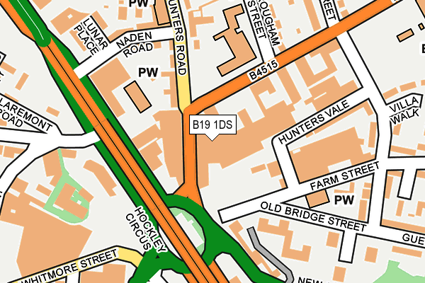
B19 1DS is located in the Newtown electoral ward, within the metropolitan district of Birmingham and the English Parliamentary constituency of Birmingham, Ladywood. The Sub Integrated Care Board (ICB) Location is NHS Birmingham and Solihull ICB - 15E and the police force is West Midlands. This postcode has been in use since January 1980.


GetTheData
Source: OS OpenMap – Local (Ordnance Survey)
Source: OS VectorMap District (Ordnance Survey)
Licence: Open Government Licence (requires attribution)
| Easting | 405894 |
| Northing | 288732 |
| Latitude | 52.496464 |
| Longitude | -1.914613 |
GetTheData
Source: Open Postcode Geo
Licence: Open Government Licence
| Country | England |
| Postcode District | B19 |
➜ See where B19 is on a map ➜ Where is Birmingham? | |
GetTheData
Source: Land Registry Price Paid Data
Licence: Open Government Licence
Elevation or altitude of B19 1DS as distance above sea level:
| Metres | Feet | |
|---|---|---|
| Elevation | 120m | 394ft |
Elevation is measured from the approximate centre of the postcode, to the nearest point on an OS contour line from OS Terrain 50, which has contour spacing of ten vertical metres.
➜ How high above sea level am I? Find the elevation of your current position using your device's GPS.
GetTheData
Source: Open Postcode Elevation
Licence: Open Government Licence
| Ward | Newtown |
| Constituency | Birmingham, Ladywood |
GetTheData
Source: ONS Postcode Database
Licence: Open Government Licence
| Hockley Circus (Hunters Rd) | Hockley | 36m |
| Hockley Circus (Hunters Rd) | Hockley | 40m |
| Hockley Circus (Soho Hill) | Hockley | 108m |
| Hockley Circus (Soho Hill) | Hockley | 139m |
| Hockley Circus (Soho Hill) | Hockley | 142m |
| Jewellery Quarter (Midland Metro Stop) (Vyse St Hockley) | Jewellery Quarter | 763m |
| Soho Benson Road (Midland Metro Stop) (Benson Road) | Winson Green | 1,124m |
| St Paul's (Midland Metro Stop) (Livery Street) | Jewellery Quarter | 1,310m |
| Snow Hill (Midland Metro Stop) (Colmore Row) | Birmingham | 1,776m |
| Jewellery Quarter Station | 0.8km |
| Birmingham Snow Hill Station | 1.8km |
| Birmingham New Street Station | 2.3km |
GetTheData
Source: NaPTAN
Licence: Open Government Licence
GetTheData
Source: ONS Postcode Database
Licence: Open Government Licence


➜ Get more ratings from the Food Standards Agency
GetTheData
Source: Food Standards Agency
Licence: FSA terms & conditions
| Last Collection | |||
|---|---|---|---|
| Location | Mon-Fri | Sat | Distance |
| New John St West / Hockley Hil | 18:30 | 12:30 | 202m |
| 88 Soho Hill / Naden Road | 17:45 | 12:30 | 288m |
| 72 Nursery Road | 17:30 | 12:30 | 390m |
GetTheData
Source: Dracos
Licence: Creative Commons Attribution-ShareAlike
The below table lists the International Territorial Level (ITL) codes (formerly Nomenclature of Territorial Units for Statistics (NUTS) codes) and Local Administrative Units (LAU) codes for B19 1DS:
| ITL 1 Code | Name |
|---|---|
| TLG | West Midlands (England) |
| ITL 2 Code | Name |
| TLG3 | West Midlands |
| ITL 3 Code | Name |
| TLG31 | Birmingham |
| LAU 1 Code | Name |
| E08000025 | Birmingham |
GetTheData
Source: ONS Postcode Directory
Licence: Open Government Licence
The below table lists the Census Output Area (OA), Lower Layer Super Output Area (LSOA), and Middle Layer Super Output Area (MSOA) for B19 1DS:
| Code | Name | |
|---|---|---|
| OA | E00045198 | |
| LSOA | E01033638 | Birmingham 049F |
| MSOA | E02001875 | Birmingham 049 |
GetTheData
Source: ONS Postcode Directory
Licence: Open Government Licence
| B19 1DP | Hunters Road | 68m |
| B19 1AA | Soho Hill | 97m |
| B19 1DU | Hunters Road | 136m |
| B19 1DY | Naden Road | 170m |
| B19 2TZ | Farm Street | 206m |
| B19 1PJ | Brougham Street | 209m |
| B19 1BA | Soho Hill | 210m |
| B19 1EA | Spring Grove | 223m |
| B19 2XL | Villa Street | 227m |
| B19 1AD | Soho Hill | 238m |
GetTheData
Source: Open Postcode Geo; Land Registry Price Paid Data
Licence: Open Government Licence