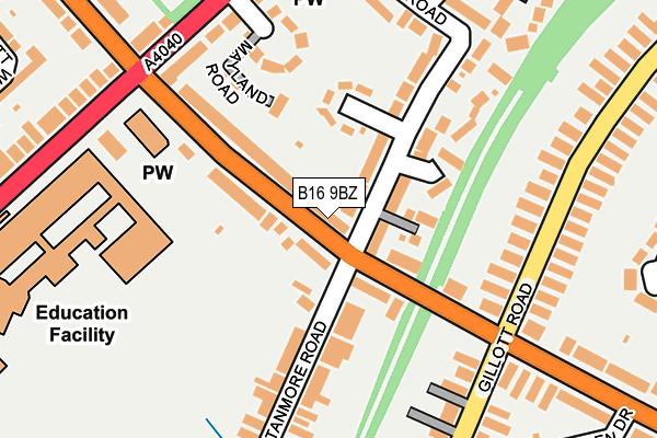
B16 9BZ is located in the North Edgbaston electoral ward, within the metropolitan district of Birmingham and the English Parliamentary constituency of Birmingham, Ladywood. The Sub Integrated Care Board (ICB) Location is NHS Birmingham and Solihull ICB - 15E and the police force is West Midlands. This postcode has been in use since September 1991.


GetTheData
Source: OS OpenMap – Local (Ordnance Survey)
Source: OS VectorMap District (Ordnance Survey)
Licence: Open Government Licence (requires attribution)
| Easting | 403368 |
| Northing | 286603 |
| Latitude | 52.477345 |
| Longitude | -1.951841 |
GetTheData
Source: Open Postcode Geo
Licence: Open Government Licence
| Country | England |
| Postcode District | B16 |
➜ See where B16 is on a map ➜ Where is Birmingham? | |
GetTheData
Source: Land Registry Price Paid Data
Licence: Open Government Licence
Elevation or altitude of B16 9BZ as distance above sea level:
| Metres | Feet | |
|---|---|---|
| Elevation | 170m | 558ft |
Elevation is measured from the approximate centre of the postcode, to the nearest point on an OS contour line from OS Terrain 50, which has contour spacing of ten vertical metres.
➜ How high above sea level am I? Find the elevation of your current position using your device's GPS.
GetTheData
Source: Open Postcode Elevation
Licence: Open Government Licence
| Ward | North Edgbaston |
| Constituency | Birmingham, Ladywood |
GetTheData
Source: ONS Postcode Database
Licence: Open Government Licence
| Stanmore Rd (Portland Rd) | Rotton Park | 105m |
| Stanmore Rd (Portland Rd) | Rotton Park | 139m |
| City Rd (Portland Rd) | Rotton Park | 184m |
| George Dixon School (City Rd) | Rotton Park | 226m |
| George Dixon School (City Rd) | Rotton Park | 228m |
| Smethwick Rolfe Street Station | 2.5km |
| Five Ways Station | 2.7km |
| Jewellery Quarter Station | 2.9km |
GetTheData
Source: NaPTAN
Licence: Open Government Licence
GetTheData
Source: ONS Postcode Database
Licence: Open Government Licence


➜ Get more ratings from the Food Standards Agency
GetTheData
Source: Food Standards Agency
Licence: FSA terms & conditions
| Last Collection | |||
|---|---|---|---|
| Location | Mon-Fri | Sat | Distance |
| Portland Road / Gillott Road | 17:45 | 12:30 | 209m |
| City Road / Portland Road | 17:45 | 12:30 | 214m |
| Rotton Park St | 17:45 | 12:30 | 428m |
GetTheData
Source: Dracos
Licence: Creative Commons Attribution-ShareAlike
The below table lists the International Territorial Level (ITL) codes (formerly Nomenclature of Territorial Units for Statistics (NUTS) codes) and Local Administrative Units (LAU) codes for B16 9BZ:
| ITL 1 Code | Name |
|---|---|
| TLG | West Midlands (England) |
| ITL 2 Code | Name |
| TLG3 | West Midlands |
| ITL 3 Code | Name |
| TLG31 | Birmingham |
| LAU 1 Code | Name |
| E08000025 | Birmingham |
GetTheData
Source: ONS Postcode Directory
Licence: Open Government Licence
The below table lists the Census Output Area (OA), Lower Layer Super Output Area (LSOA), and Middle Layer Super Output Area (MSOA) for B16 9BZ:
| Code | Name | |
|---|---|---|
| OA | E00046373 | |
| LSOA | E01009145 | Birmingham 060D |
| MSOA | E02001886 | Birmingham 060 |
GetTheData
Source: ONS Postcode Directory
Licence: Open Government Licence
| B16 9TD | Portland Road | 75m |
| B16 9SS | Portland Road | 85m |
| B16 0TA | Newnham Road | 109m |
| B16 0SX | Stanmore Road | 109m |
| B16 0NG | Mayland Road | 149m |
| B16 9SU | Stanmore Road | 157m |
| B16 9TB | Stanmore Road | 160m |
| B16 0RP | Gillott Road | 187m |
| B16 0NE | City Road | 203m |
| B16 0TE | Ravenshaw Road | 203m |
GetTheData
Source: Open Postcode Geo; Land Registry Price Paid Data
Licence: Open Government Licence