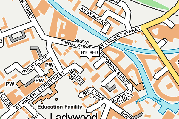
B16 8ED lies on Botany Walk in Birmingham. B16 8ED is located in the Ladywood electoral ward, within the metropolitan district of Birmingham and the English Parliamentary constituency of Birmingham, Ladywood. The Sub Integrated Care Board (ICB) Location is NHS Birmingham and Solihull ICB - 15E and the police force is West Midlands. This postcode has been in use since January 1980.


GetTheData
Source: OS OpenMap – Local (Ordnance Survey)
Source: OS VectorMap District (Ordnance Survey)
Licence: Open Government Licence (requires attribution)
| Easting | 405490 |
| Northing | 286733 |
| Latitude | 52.478512 |
| Longitude | -1.920591 |
GetTheData
Source: Open Postcode Geo
Licence: Open Government Licence
| Street | Botany Walk |
| Town/City | Birmingham |
| Country | England |
| Postcode District | B16 |
➜ See where B16 is on a map ➜ Where is Birmingham? | |
GetTheData
Source: Land Registry Price Paid Data
Licence: Open Government Licence
Elevation or altitude of B16 8ED as distance above sea level:
| Metres | Feet | |
|---|---|---|
| Elevation | 140m | 459ft |
Elevation is measured from the approximate centre of the postcode, to the nearest point on an OS contour line from OS Terrain 50, which has contour spacing of ten vertical metres.
➜ How high above sea level am I? Find the elevation of your current position using your device's GPS.
GetTheData
Source: Open Postcode Elevation
Licence: Open Government Licence
| Ward | Ladywood |
| Constituency | Birmingham, Ladywood |
GetTheData
Source: ONS Postcode Database
Licence: Open Government Licence
| St Vincent St (Sheepcote St) | National Indoor Arena | 207m |
| Ladywood Social Club (Ladywood Middleway) | Ladywood | 369m |
| Ledsam St (Ladywood Middleway) | Ladywood | 373m |
| Ladywood Social Club (Ladywood Middleway) | Ladywood | 389m |
| King Edwards Rd (Saint Vincent St) | National Indoor Arena | 391m |
| Jewellery Quarter (Midland Metro Stop) (Vyse St Hockley) | Jewellery Quarter | 1,340m |
| Grand Central New Street (Midland Metro Stop) (Stephenson Street) | Birmingham | 1,446m |
| St Paul's (Midland Metro Stop) (Livery Street) | Jewellery Quarter | 1,451m |
| Snow Hill (Midland Metro Stop) (Colmore Row) | Birmingham | 1,562m |
| Five Ways Station | 1km |
| Jewellery Quarter Station | 1.3km |
| Birmingham New Street Station | 1.4km |
GetTheData
Source: NaPTAN
Licence: Open Government Licence
| Percentage of properties with Next Generation Access | 100.0% |
| Percentage of properties with Superfast Broadband | 100.0% |
| Percentage of properties with Ultrafast Broadband | 100.0% |
| Percentage of properties with Full Fibre Broadband | 0.0% |
Superfast Broadband is between 30Mbps and 300Mbps
Ultrafast Broadband is > 300Mbps
| Percentage of properties unable to receive 2Mbps | 0.0% |
| Percentage of properties unable to receive 5Mbps | 0.0% |
| Percentage of properties unable to receive 10Mbps | 0.0% |
| Percentage of properties unable to receive 30Mbps | 0.0% |
GetTheData
Source: Ofcom
Licence: Ofcom Terms of Use (requires attribution)
Estimated total energy consumption in B16 8ED by fuel type, 2015.
| Consumption (kWh) | 70,689 |
|---|---|
| Meter count | 6 |
| Mean (kWh/meter) | 11,781 |
| Median (kWh/meter) | 10,853 |
GetTheData
Source: Postcode level gas estimates: 2015 (experimental)
Source: Postcode level electricity estimates: 2015 (experimental)
Licence: Open Government Licence
GetTheData
Source: ONS Postcode Database
Licence: Open Government Licence


➜ Get more ratings from the Food Standards Agency
GetTheData
Source: Food Standards Agency
Licence: FSA terms & conditions
| Last Collection | |||
|---|---|---|---|
| Location | Mon-Fri | Sat | Distance |
| St Vincent St Post Office | 17:30 | 12:30 | 188m |
| Ladywood Road | 17:30 | 12:30 | 318m |
| Sheepcotestreet | 17:30 | 12:30 | 371m |
GetTheData
Source: Dracos
Licence: Creative Commons Attribution-ShareAlike
The below table lists the International Territorial Level (ITL) codes (formerly Nomenclature of Territorial Units for Statistics (NUTS) codes) and Local Administrative Units (LAU) codes for B16 8ED:
| ITL 1 Code | Name |
|---|---|
| TLG | West Midlands (England) |
| ITL 2 Code | Name |
| TLG3 | West Midlands |
| ITL 3 Code | Name |
| TLG31 | Birmingham |
| LAU 1 Code | Name |
| E08000025 | Birmingham |
GetTheData
Source: ONS Postcode Directory
Licence: Open Government Licence
The below table lists the Census Output Area (OA), Lower Layer Super Output Area (LSOA), and Middle Layer Super Output Area (MSOA) for B16 8ED:
| Code | Name | |
|---|---|---|
| OA | E00046383 | |
| LSOA | E01009141 | Birmingham 137A |
| MSOA | E02006898 | Birmingham 137 |
GetTheData
Source: ONS Postcode Directory
Licence: Open Government Licence
| B16 8EG | Ladycroft | 41m |
| B16 8EJ | Bellcroft | 77m |
| B16 8AH | Sheepcote Street | 79m |
| B16 8AT | Sheepcote Street | 79m |
| B16 8EX | Ashton Croft | 99m |
| B16 8DY | Knoll Croft | 121m |
| B16 8EY | St Vincent Street | 130m |
| B16 8GY | Browning Street | 137m |
| B16 8EN | Kilby Avenue | 142m |
| B16 8EW | Kilby Avenue | 156m |
GetTheData
Source: Open Postcode Geo; Land Registry Price Paid Data
Licence: Open Government Licence