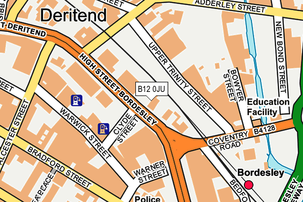
B12 0JU lies on High Street in Bordesley, Birmingham. B12 0JU is located in the Bordesley & Highgate electoral ward, within the metropolitan district of Birmingham and the English Parliamentary constituency of Birmingham, Ladywood. The Sub Integrated Care Board (ICB) Location is NHS Birmingham and Solihull ICB - 15E and the police force is West Midlands. This postcode has been in use since January 1980.


GetTheData
Source: OS OpenMap – Local (Ordnance Survey)
Source: OS VectorMap District (Ordnance Survey)
Licence: Open Government Licence (requires attribution)
| Easting | 408268 |
| Northing | 286151 |
| Latitude | 52.473231 |
| Longitude | -1.879708 |
GetTheData
Source: Open Postcode Geo
Licence: Open Government Licence
| Street | High Street |
| Locality | Bordesley |
| Town/City | Birmingham |
| Country | England |
| Postcode District | B12 |
➜ See where B12 is on a map ➜ Where is Birmingham? | |
GetTheData
Source: Land Registry Price Paid Data
Licence: Open Government Licence
Elevation or altitude of B12 0JU as distance above sea level:
| Metres | Feet | |
|---|---|---|
| Elevation | 110m | 361ft |
Elevation is measured from the approximate centre of the postcode, to the nearest point on an OS contour line from OS Terrain 50, which has contour spacing of ten vertical metres.
➜ How high above sea level am I? Find the elevation of your current position using your device's GPS.
GetTheData
Source: Open Postcode Elevation
Licence: Open Government Licence
| Ward | Bordesley & Highgate |
| Constituency | Birmingham, Ladywood |
GetTheData
Source: ONS Postcode Database
Licence: Open Government Licence
130, HIGH STREET, BORDESLEY, BIRMINGHAM, B12 0JU 2002 1 AUG £70,000 |
GetTheData
Source: HM Land Registry Price Paid Data
Licence: Contains HM Land Registry data © Crown copyright and database right 2025. This data is licensed under the Open Government Licence v3.0.
| Adderley St (High St) | Deritend | 97m |
| Adderley St (High St) | Deritend | 119m |
| Bordesley Rail Station (Coventry Rd) | Bordesley | 136m |
| Bordesley Rail Station (Coventry Rd) | Bordesley | 137m |
| Adderley St (High St) | Deritend | 154m |
| Corporation Street (Midland Metro Stop) (Corporation Street) | Birmingham | 1,396m |
| Grand Central New Street (Midland Metro Stop) (Stephenson Street) | Birmingham | 1,460m |
| Bull Street (Midland Metro Stop) (Bull Street) | Birmingham | 1,481m |
| Snow Hill (Midland Metro Stop) (Colmore Row) | Birmingham | 1,752m |
| Bordesley Station | 0.2km |
| Birmingham Moor Street Station | 1.1km |
| Birmingham New Street Station | 1.5km |
GetTheData
Source: NaPTAN
Licence: Open Government Licence
GetTheData
Source: ONS Postcode Database
Licence: Open Government Licence
➜ Get more ratings from the Food Standards Agency
GetTheData
Source: Food Standards Agency
Licence: FSA terms & conditions
| Last Collection | |||
|---|---|---|---|
| Location | Mon-Fri | Sat | Distance |
| 50 Coventry Road Near Watery Lan | 17:30 | 11:30 | 178m |
| Warner St / Bradford St | 17:30 | 12:30 | 201m |
| Bradford St / Alcestor St | 17:30 | 12:30 | 276m |
GetTheData
Source: Dracos
Licence: Creative Commons Attribution-ShareAlike
The below table lists the International Territorial Level (ITL) codes (formerly Nomenclature of Territorial Units for Statistics (NUTS) codes) and Local Administrative Units (LAU) codes for B12 0JU:
| ITL 1 Code | Name |
|---|---|
| TLG | West Midlands (England) |
| ITL 2 Code | Name |
| TLG3 | West Midlands |
| ITL 3 Code | Name |
| TLG31 | Birmingham |
| LAU 1 Code | Name |
| E08000025 | Birmingham |
GetTheData
Source: ONS Postcode Directory
Licence: Open Government Licence
The below table lists the Census Output Area (OA), Lower Layer Super Output Area (LSOA), and Middle Layer Super Output Area (MSOA) for B12 0JU:
| Code | Name | |
|---|---|---|
| OA | E00046660 | |
| LSOA | E01009200 | Birmingham 139A |
| MSOA | E02006900 | Birmingham 139 |
GetTheData
Source: ONS Postcode Directory
Licence: Open Government Licence
| B9 4EG | Upper Trinity Street | 141m |
| B9 4ED | Adderley Street | 169m |
| B12 0RG | Bradford Street | 189m |
| B12 0JD | Bradford Street | 191m |
| B12 0NW | Warwick Street | 215m |
| B12 0ND | Bradford Street | 237m |
| B12 0NS | Bradford Street | 247m |
| B12 0NX | Alcester Street | 253m |
| B12 0LD | High Street | 255m |
| B12 0NZ | Bradford Street | 259m |
GetTheData
Source: Open Postcode Geo; Land Registry Price Paid Data
Licence: Open Government Licence