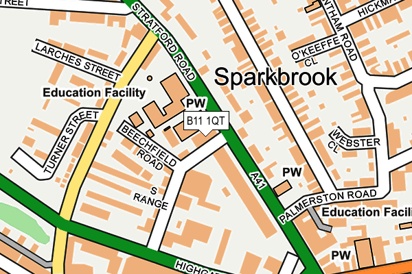
B11 1QT lies on Stratford Road in Sparkhill, Birmingham. B11 1QT is located in the Sparkbrook & Balsall Heath East electoral ward, within the metropolitan district of Birmingham and the English Parliamentary constituency of Birmingham, Hall Green. The Sub Integrated Care Board (ICB) Location is NHS Birmingham and Solihull ICB - 15E and the police force is West Midlands. This postcode has been in use since January 1980.


GetTheData
Source: OS OpenMap – Local (Ordnance Survey)
Source: OS VectorMap District (Ordnance Survey)
Licence: Open Government Licence (requires attribution)
| Easting | 408689 |
| Northing | 284762 |
| Latitude | 52.460737 |
| Longitude | -1.873546 |
GetTheData
Source: Open Postcode Geo
Licence: Open Government Licence
| Street | Stratford Road |
| Locality | Sparkhill |
| Town/City | Birmingham |
| Country | England |
| Postcode District | B11 |
➜ See where B11 is on a map ➜ Where is Birmingham? | |
GetTheData
Source: Land Registry Price Paid Data
Licence: Open Government Licence
Elevation or altitude of B11 1QT as distance above sea level:
| Metres | Feet | |
|---|---|---|
| Elevation | 120m | 394ft |
Elevation is measured from the approximate centre of the postcode, to the nearest point on an OS contour line from OS Terrain 50, which has contour spacing of ten vertical metres.
➜ How high above sea level am I? Find the elevation of your current position using your device's GPS.
GetTheData
Source: Open Postcode Elevation
Licence: Open Government Licence
| Ward | Sparkbrook & Balsall Heath East |
| Constituency | Birmingham, Hall Green |
GetTheData
Source: ONS Postcode Database
Licence: Open Government Licence
| Stratford Road (Mole St) | Sparkbrook | 11m |
| Palmerston Rd (Stratford Rd) | Sparkbrook | 105m |
| Ladypool Rd (Stratford Rd) | Sparkbrook | 109m |
| Palmerston Rd (Stratford Rd) | Sparkbrook | 114m |
| Ladypool Rd (Stratford Rd) | Sparkbrook | 132m |
| Small Heath Station | 1km |
| Bordesley Station | 1.3km |
| Birmingham Moor Street Station | 2.4km |
GetTheData
Source: NaPTAN
Licence: Open Government Licence
GetTheData
Source: ONS Postcode Database
Licence: Open Government Licence


➜ Get more ratings from the Food Standards Agency
GetTheData
Source: Food Standards Agency
Licence: FSA terms & conditions
| Last Collection | |||
|---|---|---|---|
| Location | Mon-Fri | Sat | Distance |
| Brunswick Road / Stoney Lane | 18:15 | 12:30 | 198m |
| Grantham Road / Hickman Road | 18:15 | 12:30 | 264m |
| Camp Hill Del Office | 17:45 | 12:30 | 333m |
GetTheData
Source: Dracos
Licence: Creative Commons Attribution-ShareAlike
The below table lists the International Territorial Level (ITL) codes (formerly Nomenclature of Territorial Units for Statistics (NUTS) codes) and Local Administrative Units (LAU) codes for B11 1QT:
| ITL 1 Code | Name |
|---|---|
| TLG | West Midlands (England) |
| ITL 2 Code | Name |
| TLG3 | West Midlands |
| ITL 3 Code | Name |
| TLG31 | Birmingham |
| LAU 1 Code | Name |
| E08000025 | Birmingham |
GetTheData
Source: ONS Postcode Directory
Licence: Open Government Licence
The below table lists the Census Output Area (OA), Lower Layer Super Output Area (LSOA), and Middle Layer Super Output Area (MSOA) for B11 1QT:
| Code | Name | |
|---|---|---|
| OA | E00047483 | |
| LSOA | E01009371 | Birmingham 077D |
| MSOA | E02001903 | Birmingham 077 |
GetTheData
Source: ONS Postcode Directory
Licence: Open Government Licence
| B11 1AD | Stratford Road | 82m |
| B11 1XA | Mole Street | 92m |
| B11 1XB | Beechfield Road | 96m |
| B11 1LL | Gladstone Road | 122m |
| B11 1LN | Gladstone Road | 146m |
| B11 1XF | Ladypool Avenue | 157m |
| B12 8DN | Highgate Road | 159m |
| B11 1LW | Gladstone Road | 159m |
| B11 1XD | Ladypool Road | 166m |
| B11 1LP | Gladstone Road | 167m |
GetTheData
Source: Open Postcode Geo; Land Registry Price Paid Data
Licence: Open Government Licence