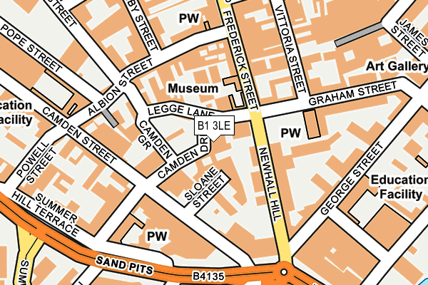
B1 3LE is located in the Soho & Jewellery Quarter electoral ward, within the metropolitan district of Birmingham and the English Parliamentary constituency of Birmingham, Ladywood. The Sub Integrated Care Board (ICB) Location is NHS Birmingham and Solihull ICB - 15E and the police force is West Midlands. This postcode has been in use since October 2017.


GetTheData
Source: OS OpenMap – Local (Ordnance Survey)
Source: OS VectorMap District (Ordnance Survey)
Licence: Open Government Licence (requires attribution)
| Easting | 406060 |
| Northing | 287336 |
| Latitude | 52.483927 |
| Longitude | -1.912188 |
GetTheData
Source: Open Postcode Geo
Licence: Open Government Licence
| Country | England |
| Postcode District | B1 |
➜ See where B1 is on a map ➜ Where is Birmingham? | |
GetTheData
Source: Land Registry Price Paid Data
Licence: Open Government Licence
| Ward | Soho & Jewellery Quarter |
| Constituency | Birmingham, Ladywood |
GetTheData
Source: ONS Postcode Database
Licence: Open Government Licence
| Graham St (Frederick St) | Jewellery Quarter | 92m |
| George St (Newhall Hill) | National Indoor Arena | 164m |
| Vittoria St (Graham St) | Jewellery Quarter | 190m |
| Nelson St (Sandpits) | National Indoor Arena | 195m |
| Regent Place (Vittoria St) | Jewellery Quarter | 216m |
| St Paul's (Midland Metro Stop) (Livery Street) | Jewellery Quarter | 639m |
| Jewellery Quarter (Midland Metro Stop) (Vyse St Hockley) | Jewellery Quarter | 643m |
| Snow Hill (Midland Metro Stop) (Colmore Row) | Birmingham | 886m |
| Grand Central New Street (Midland Metro Stop) (Stephenson Street) | Birmingham | 1,055m |
| Bull Street (Midland Metro Stop) (Bull Street) | Birmingham | 1,102m |
| Jewellery Quarter Station | 0.6km |
| Birmingham Snow Hill Station | 0.9km |
| Birmingham New Street Station | 1.1km |
GetTheData
Source: NaPTAN
Licence: Open Government Licence
| Percentage of properties with Next Generation Access | 100.0% |
| Percentage of properties with Superfast Broadband | 100.0% |
| Percentage of properties with Ultrafast Broadband | 0.0% |
| Percentage of properties with Full Fibre Broadband | 0.0% |
Superfast Broadband is between 30Mbps and 300Mbps
Ultrafast Broadband is > 300Mbps
| Median download speed | 39.1Mbps |
| Average download speed | 45.8Mbps |
| Maximum download speed | 159.86Mbps |
| Median upload speed | 9.8Mbps |
| Average upload speed | 9.4Mbps |
| Maximum upload speed | 22.03Mbps |
| Percentage of properties unable to receive 2Mbps | 0.0% |
| Percentage of properties unable to receive 5Mbps | 0.0% |
| Percentage of properties unable to receive 10Mbps | 0.0% |
| Percentage of properties unable to receive 30Mbps | 0.0% |
GetTheData
Source: Ofcom
Licence: Ofcom Terms of Use (requires attribution)
GetTheData
Source: ONS Postcode Database
Licence: Open Government Licence

➜ Get more ratings from the Food Standards Agency
GetTheData
Source: Food Standards Agency
Licence: FSA terms & conditions
| Last Collection | |||
|---|---|---|---|
| Location | Mon-Fri | Sat | Distance |
| Frederick St / Legge Lane | 18:30 | 12:30 | 73m |
| Camden St / Albion St | 18:30 | 12:30 | 190m |
| The Parade Summerhill Road | 17:30 | 12:30 | 266m |
GetTheData
Source: Dracos
Licence: Creative Commons Attribution-ShareAlike
The below table lists the International Territorial Level (ITL) codes (formerly Nomenclature of Territorial Units for Statistics (NUTS) codes) and Local Administrative Units (LAU) codes for B1 3LE:
| ITL 1 Code | Name |
|---|---|
| TLG | West Midlands (England) |
| ITL 2 Code | Name |
| TLG3 | West Midlands |
| ITL 3 Code | Name |
| TLG31 | Birmingham |
| LAU 1 Code | Name |
| E08000025 | Birmingham |
GetTheData
Source: ONS Postcode Directory
Licence: Open Government Licence
The below table lists the Census Output Area (OA), Lower Layer Super Output Area (LSOA), and Middle Layer Super Output Area (MSOA) for B1 3LE:
| Code | Name | |
|---|---|---|
| OA | E00175684 | |
| LSOA | E01033565 | Birmingham 137B |
| MSOA | E02006898 | Birmingham 137 |
GetTheData
Source: ONS Postcode Directory
Licence: Open Government Licence
| B1 3LD | Legge Lane | 71m |
| B1 3JN | Newhall Hill | 81m |
| B1 3JG | Newhall Hill | 83m |
| B1 3HS | Frederick Street | 103m |
| B1 3PE | Vittoria Street | 116m |
| B1 3EA | Albion Street | 118m |
| B1 3JA | Newhall Hill | 122m |
| B1 3HE | Frederick Street | 127m |
| B3 1DR | Newhall Court | 142m |
| B1 3AA | Albion Street | 152m |
GetTheData
Source: Open Postcode Geo; Land Registry Price Paid Data
Licence: Open Government Licence