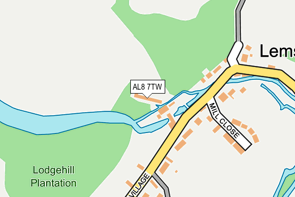
AL8 7TW is located in the Hatfield Villages electoral ward, within the local authority district of Welwyn Hatfield and the English Parliamentary constituency of Welwyn Hatfield. The Sub Integrated Care Board (ICB) Location is NHS Hertfordshire and West Essex ICB - 06K and the police force is Hertfordshire. This postcode has been in use since April 2005.


GetTheData
Source: OS OpenMap – Local (Ordnance Survey)
Source: OS VectorMap District (Ordnance Survey)
Licence: Open Government Licence (requires attribution)
| Easting | 521902 |
| Northing | 212413 |
| Latitude | 51.797095 |
| Longitude | -0.233658 |
GetTheData
Source: Open Postcode Geo
Licence: Open Government Licence
| Country | England |
| Postcode District | AL8 |
➜ See where AL8 is on a map ➜ Where is Lemsford? | |
GetTheData
Source: Land Registry Price Paid Data
Licence: Open Government Licence
Elevation or altitude of AL8 7TW as distance above sea level:
| Metres | Feet | |
|---|---|---|
| Elevation | 70m | 230ft |
Elevation is measured from the approximate centre of the postcode, to the nearest point on an OS contour line from OS Terrain 50, which has contour spacing of ten vertical metres.
➜ How high above sea level am I? Find the elevation of your current position using your device's GPS.
GetTheData
Source: Open Postcode Elevation
Licence: Open Government Licence
| Ward | Hatfield Villages |
| Constituency | Welwyn Hatfield |
GetTheData
Source: ONS Postcode Database
Licence: Open Government Licence
| The Sun Ph (Lemsford Village) | Lemsford | 80m |
| The Sun Ph (Marford Road) | Lemsford | 111m |
| Lemsford Corner (Valley Road) | Welwyn Garden City | 642m |
| Lemsford Corner (Valley Road) | Welwyn Garden City | 661m |
| Crooked Chimney Ph (Marford Road) | Cromer Hyde | 911m |
| Welwyn Garden City Station | 2.1km |
| Hatfield (Herts) Station | 3.9km |
| Welwyn North Station | 4.1km |
GetTheData
Source: NaPTAN
Licence: Open Government Licence
GetTheData
Source: ONS Postcode Database
Licence: Open Government Licence


➜ Get more ratings from the Food Standards Agency
GetTheData
Source: Food Standards Agency
Licence: FSA terms & conditions
| Last Collection | |||
|---|---|---|---|
| Location | Mon-Fri | Sat | Distance |
| Lemsford Village | 16:00 | 10:30 | 114m |
| Cromer Hyde | 16:00 | 07:15 | 920m |
| Applecroft Road | 17:30 | 12:00 | 983m |
GetTheData
Source: Dracos
Licence: Creative Commons Attribution-ShareAlike
| Risk of AL8 7TW flooding from rivers and sea | Medium |
| ➜ AL8 7TW flood map | |
GetTheData
Source: Open Flood Risk by Postcode
Licence: Open Government Licence
The below table lists the International Territorial Level (ITL) codes (formerly Nomenclature of Territorial Units for Statistics (NUTS) codes) and Local Administrative Units (LAU) codes for AL8 7TW:
| ITL 1 Code | Name |
|---|---|
| TLH | East |
| ITL 2 Code | Name |
| TLH2 | Bedfordshire and Hertfordshire |
| ITL 3 Code | Name |
| TLH23 | Hertfordshire CC |
| LAU 1 Code | Name |
| E07000241 | Welwyn Hatfield |
GetTheData
Source: ONS Postcode Directory
Licence: Open Government Licence
The below table lists the Census Output Area (OA), Lower Layer Super Output Area (LSOA), and Middle Layer Super Output Area (MSOA) for AL8 7TW:
| Code | Name | |
|---|---|---|
| OA | E00121520 | |
| LSOA | E01033313 | Welwyn Hatfield 002F |
| MSOA | E02004981 | Welwyn Hatfield 002 |
GetTheData
Source: ONS Postcode Directory
Licence: Open Government Licence
| AL8 7TR | Lemsford Village | 127m |
| AL8 7TP | Mill Close | 185m |
| AL8 7TN | Lemsford Village | 287m |
| AL8 7TT | Brocket Road | 431m |
| AL8 7TL | Great North Road | 653m |
| AL8 6LJ | Broadfield Place | 735m |
| AL8 6LG | Attimore Road | 745m |
| AL8 6YJ | Lemsford Lane | 755m |
| AL8 6YS | Newfields | 775m |
| AL8 6YT | Newfields | 775m |
GetTheData
Source: Open Postcode Geo; Land Registry Price Paid Data
Licence: Open Government Licence