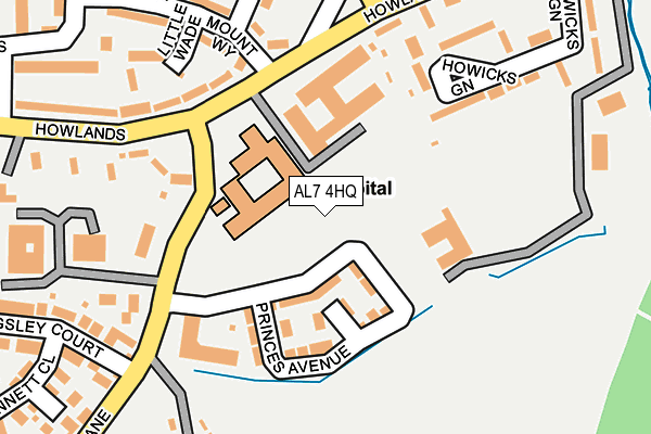
AL7 4HQ lies on Howlands in Welwyn Garden City. AL7 4HQ is located in the Howlands electoral ward, within the local authority district of Welwyn Hatfield and the English Parliamentary constituency of Welwyn Hatfield. The Sub Integrated Care Board (ICB) Location is NHS Hertfordshire and West Essex ICB - 06K and the police force is Hertfordshire. This postcode has been in use since January 1980.


GetTheData
Source: OS OpenMap – Local (Ordnance Survey)
Source: OS VectorMap District (Ordnance Survey)
Licence: Open Government Licence (requires attribution)
| Easting | 525046 |
| Northing | 210963 |
| Latitude | 51.783371 |
| Longitude | -0.188611 |
GetTheData
Source: Open Postcode Geo
Licence: Open Government Licence
| Street | Howlands |
| Town/City | Welwyn Garden City |
| Country | England |
| Postcode District | AL7 |
➜ See where AL7 is on a map ➜ Where is Welwyn Garden City? | |
GetTheData
Source: Land Registry Price Paid Data
Licence: Open Government Licence
Elevation or altitude of AL7 4HQ as distance above sea level:
| Metres | Feet | |
|---|---|---|
| Elevation | 70m | 230ft |
Elevation is measured from the approximate centre of the postcode, to the nearest point on an OS contour line from OS Terrain 50, which has contour spacing of ten vertical metres.
➜ How high above sea level am I? Find the elevation of your current position using your device's GPS.
GetTheData
Source: Open Postcode Elevation
Licence: Open Government Licence
| Ward | Howlands |
| Constituency | Welwyn Hatfield |
GetTheData
Source: ONS Postcode Database
Licence: Open Government Licence
| New Qeii Hospital (Howlands) | Welwyn Garden City | 87m |
| New Qeii Hospital (Howlands) | Welwyn Garden City | 168m |
| Ryelands (Howlands) | Welwyn Garden City | 178m |
| Ryelands (Howlands) | Welwyn Garden City | 206m |
| Howlands House (Howlands) | Welwyn Garden City | 371m |
| Welwyn Garden City Station | 2.2km |
| Hatfield (Herts) Station | 2.9km |
| Welwyn North Station | 4.5km |
GetTheData
Source: NaPTAN
Licence: Open Government Licence
GetTheData
Source: ONS Postcode Database
Licence: Open Government Licence


➜ Get more ratings from the Food Standards Agency
GetTheData
Source: Food Standards Agency
Licence: FSA terms & conditions
| Last Collection | |||
|---|---|---|---|
| Location | Mon-Fri | Sat | Distance |
| Howlands | 17:30 | 12:00 | 129m |
| Beehive Lane | 17:30 | 12:00 | 352m |
| Hollyrush | 17:30 | 12:00 | 528m |
GetTheData
Source: Dracos
Licence: Creative Commons Attribution-ShareAlike
The below table lists the International Territorial Level (ITL) codes (formerly Nomenclature of Territorial Units for Statistics (NUTS) codes) and Local Administrative Units (LAU) codes for AL7 4HQ:
| ITL 1 Code | Name |
|---|---|
| TLH | East |
| ITL 2 Code | Name |
| TLH2 | Bedfordshire and Hertfordshire |
| ITL 3 Code | Name |
| TLH23 | Hertfordshire CC |
| LAU 1 Code | Name |
| E07000241 | Welwyn Hatfield |
GetTheData
Source: ONS Postcode Directory
Licence: Open Government Licence
The below table lists the Census Output Area (OA), Lower Layer Super Output Area (LSOA), and Middle Layer Super Output Area (MSOA) for AL7 4HQ:
| Code | Name | |
|---|---|---|
| OA | E00173214 | |
| LSOA | E01023946 | Welwyn Hatfield 008D |
| MSOA | E02004987 | Welwyn Hatfield 008 |
GetTheData
Source: ONS Postcode Directory
Licence: Open Government Licence
| AL7 4HE | Howlands | 103m |
| AL7 4HD | Howlands | 114m |
| AL7 4LE | Little Wade | 140m |
| AL7 4LD | Mount Way | 144m |
| AL7 4LF | Mount Way | 151m |
| AL7 4HN | Howlands | 167m |
| AL7 4LG | The Wade | 209m |
| AL7 4LQ | Ryelands | 225m |
| AL7 4HL | Ascots Lane | 231m |
| AL7 4HG | Howlands | 235m |
GetTheData
Source: Open Postcode Geo; Land Registry Price Paid Data
Licence: Open Government Licence