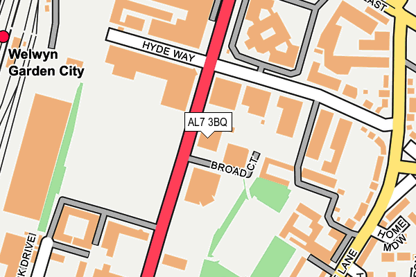
AL7 3BQ lies on Broadwater Road in Welwyn Garden City. AL7 3BQ is located in the Peartree electoral ward, within the local authority district of Welwyn Hatfield and the English Parliamentary constituency of Welwyn Hatfield. The Sub Integrated Care Board (ICB) Location is NHS Hertfordshire and West Essex ICB - 06K and the police force is Hertfordshire. This postcode has been in use since January 1980.


GetTheData
Source: OS OpenMap – Local (Ordnance Survey)
Source: OS VectorMap District (Ordnance Survey)
Licence: Open Government Licence (requires attribution)
| Easting | 524253 |
| Northing | 212731 |
| Latitude | 51.799436 |
| Longitude | -0.199469 |
GetTheData
Source: Open Postcode Geo
Licence: Open Government Licence
| Street | Broadwater Road |
| Town/City | Welwyn Garden City |
| Country | England |
| Postcode District | AL7 |
➜ See where AL7 is on a map ➜ Where is Welwyn Garden City? | |
GetTheData
Source: Land Registry Price Paid Data
Licence: Open Government Licence
Elevation or altitude of AL7 3BQ as distance above sea level:
| Metres | Feet | |
|---|---|---|
| Elevation | 90m | 295ft |
Elevation is measured from the approximate centre of the postcode, to the nearest point on an OS contour line from OS Terrain 50, which has contour spacing of ten vertical metres.
➜ How high above sea level am I? Find the elevation of your current position using your device's GPS.
GetTheData
Source: Open Postcode Elevation
Licence: Open Government Licence
| Ward | Peartree |
| Constituency | Welwyn Hatfield |
GetTheData
Source: ONS Postcode Database
Licence: Open Government Licence
| Hyde Way (Broadwater Road) | Welwyn Garden City | 29m |
| Hyde Way (Broadwater Road) | Welwyn Garden City | 38m |
| Bridge Road East (Peartree Lane) | Welwyn Garden City | 277m |
| Penn Way (Broadwater Road) | Welwyn Garden City | 289m |
| Bridge Road East (Peartree Lane) | Welwyn Garden City | 310m |
| Welwyn Garden City Station | 0.4km |
| Welwyn North Station | 2.7km |
| Hatfield (Herts) Station | 4.1km |
GetTheData
Source: NaPTAN
Licence: Open Government Licence
| Median download speed | 36.6Mbps |
| Average download speed | 43.3Mbps |
| Maximum download speed | 80.00Mbps |
| Median upload speed | 5.6Mbps |
| Average upload speed | 9.6Mbps |
| Maximum upload speed | 20.00Mbps |
GetTheData
Source: Ofcom
Licence: Ofcom Terms of Use (requires attribution)
GetTheData
Source: ONS Postcode Database
Licence: Open Government Licence


➜ Get more ratings from the Food Standards Agency
GetTheData
Source: Food Standards Agency
Licence: FSA terms & conditions
| Last Collection | |||
|---|---|---|---|
| Location | Mon-Fri | Sat | Distance |
| Hyde Way | 17:30 | 12:00 | 113m |
| Peartree | 17:30 | 12:00 | 322m |
| Ravensfield Bridge Road East | 17:30 | 11:45 | 429m |
GetTheData
Source: Dracos
Licence: Creative Commons Attribution-ShareAlike
The below table lists the International Territorial Level (ITL) codes (formerly Nomenclature of Territorial Units for Statistics (NUTS) codes) and Local Administrative Units (LAU) codes for AL7 3BQ:
| ITL 1 Code | Name |
|---|---|
| TLH | East |
| ITL 2 Code | Name |
| TLH2 | Bedfordshire and Hertfordshire |
| ITL 3 Code | Name |
| TLH23 | Hertfordshire CC |
| LAU 1 Code | Name |
| E07000241 | Welwyn Hatfield |
GetTheData
Source: ONS Postcode Directory
Licence: Open Government Licence
The below table lists the Census Output Area (OA), Lower Layer Super Output Area (LSOA), and Middle Layer Super Output Area (MSOA) for AL7 3BQ:
| Code | Name | |
|---|---|---|
| OA | E00121637 | |
| LSOA | E01023954 | Welwyn Hatfield 007A |
| MSOA | E02004986 | Welwyn Hatfield 007 |
GetTheData
Source: ONS Postcode Directory
Licence: Open Government Licence
| AL7 3UW | Peartree Lane | 146m |
| AL7 3AE | Hyde Way | 224m |
| AL7 3UH | Peartree Lane | 247m |
| AL7 3EQ | Otto Road | 251m |
| AL7 3BZ | Broadwater Road | 261m |
| AL7 3UD | Peartree Lane | 261m |
| AL7 3BH | Regent Court | 269m |
| AL7 3EF | Penn Way | 270m |
| AL7 3UN | Peartree Lane | 280m |
| AL7 3UA | Peartree Lane | 299m |
GetTheData
Source: Open Postcode Geo; Land Registry Price Paid Data
Licence: Open Government Licence