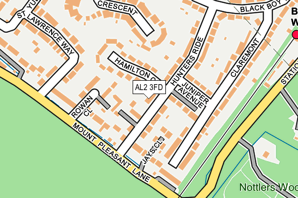
AL2 3FD is located in the St Stephen electoral ward, within the local authority district of St Albans and the English Parliamentary constituency of St Albans. The Sub Integrated Care Board (ICB) Location is NHS Hertfordshire and West Essex ICB - 06N and the police force is Hertfordshire. This postcode has been in use since April 2017.


GetTheData
Source: OS OpenMap – Local (Ordnance Survey)
Source: OS VectorMap District (Ordnance Survey)
Licence: Open Government Licence (requires attribution)
| Easting | 513183 |
| Northing | 201902 |
| Latitude | 51.704458 |
| Longitude | -0.363454 |
GetTheData
Source: Open Postcode Geo
Licence: Open Government Licence
| Country | England |
| Postcode District | AL2 |
➜ See where AL2 is on a map ➜ Where is Bricket Wood? | |
GetTheData
Source: Land Registry Price Paid Data
Licence: Open Government Licence
| Ward | St Stephen |
| Constituency | St Albans |
GetTheData
Source: ONS Postcode Database
Licence: Open Government Licence
| Hamilton Close (Hunters Ride) | Bricket Wood | 16m |
| Hamilton Close (Hunters Ride) | Bricket Wood | 54m |
| South Riding (Black Boy Wood) | Bricket Wood | 245m |
| United Reformed Church (West Riding) | Bricket Wood | 380m |
| United Reformed Church (West Riding) | Bricket Wood | 389m |
| Bricket Wood Station | 0.3km |
| How Wood (Herts) Station | 2km |
| Garston (Herts) Station | 2.4km |
GetTheData
Source: NaPTAN
Licence: Open Government Licence
| Percentage of properties with Next Generation Access | 100.0% |
| Percentage of properties with Superfast Broadband | 100.0% |
| Percentage of properties with Ultrafast Broadband | 0.0% |
| Percentage of properties with Full Fibre Broadband | 0.0% |
Superfast Broadband is between 30Mbps and 300Mbps
Ultrafast Broadband is > 300Mbps
| Percentage of properties unable to receive 2Mbps | 0.0% |
| Percentage of properties unable to receive 5Mbps | 0.0% |
| Percentage of properties unable to receive 10Mbps | 0.0% |
| Percentage of properties unable to receive 30Mbps | 0.0% |
GetTheData
Source: Ofcom
Licence: Ofcom Terms of Use (requires attribution)
GetTheData
Source: ONS Postcode Database
Licence: Open Government Licence


➜ Get more ratings from the Food Standards Agency
GetTheData
Source: Food Standards Agency
Licence: FSA terms & conditions
| Last Collection | |||
|---|---|---|---|
| Location | Mon-Fri | Sat | Distance |
| Oakwood Road Post Office | 18:30 | 12:00 | 485m |
| Ferndene | 17:30 | 12:00 | 486m |
| How Wood P.o | 18:30 | 12:00 | 1,898m |
GetTheData
Source: Dracos
Licence: Creative Commons Attribution-ShareAlike
The below table lists the International Territorial Level (ITL) codes (formerly Nomenclature of Territorial Units for Statistics (NUTS) codes) and Local Administrative Units (LAU) codes for AL2 3FD:
| ITL 1 Code | Name |
|---|---|
| TLH | East |
| ITL 2 Code | Name |
| TLH2 | Bedfordshire and Hertfordshire |
| ITL 3 Code | Name |
| TLH23 | Hertfordshire CC |
| LAU 1 Code | Name |
| E07000240 | St Albans |
GetTheData
Source: ONS Postcode Directory
Licence: Open Government Licence
The below table lists the Census Output Area (OA), Lower Layer Super Output Area (LSOA), and Middle Layer Super Output Area (MSOA) for AL2 3FD:
| Code | Name | |
|---|---|---|
| OA | E00120450 | |
| LSOA | E01023717 | St Albans 020A |
| MSOA | E02004943 | St Albans 020 |
GetTheData
Source: ONS Postcode Directory
Licence: Open Government Licence
| AL2 3LX | Hunters Ride | 49m |
| AL2 3LR | Juniper Avenue | 63m |
| AL2 3UJ | Jays Close | 84m |
| AL2 3XP | Rowan Close | 91m |
| AL2 3NA | Hamilton Close | 103m |
| AL2 3NB | Hunters Ride | 112m |
| AL2 3XW | Mount Pleasant Lane | 126m |
| AL2 3LU | Claremont | 127m |
| AL2 3XR | Mount Pleasant Lane | 133m |
| AL2 3PA | Claremont | 134m |
GetTheData
Source: Open Postcode Geo; Land Registry Price Paid Data
Licence: Open Government Licence