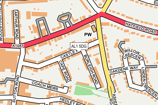
AL1 5DG lies on Castle Road in St. Albans. AL1 5DG is located in the Clarence electoral ward, within the local authority district of St Albans and the English Parliamentary constituency of St Albans. The Sub Integrated Care Board (ICB) Location is NHS Hertfordshire and West Essex ICB - 06N and the police force is Hertfordshire. This postcode has been in use since January 1980.


GetTheData
Source: OS OpenMap – Local (Ordnance Survey)
Source: OS VectorMap District (Ordnance Survey)
Licence: Open Government Licence (requires attribution)
| Easting | 516941 |
| Northing | 207238 |
| Latitude | 51.751639 |
| Longitude | -0.307329 |
GetTheData
Source: Open Postcode Geo
Licence: Open Government Licence
| Street | Castle Road |
| Town/City | St. Albans |
| Country | England |
| Postcode District | AL1 |
➜ See where AL1 is on a map ➜ Where is St Albans? | |
GetTheData
Source: Land Registry Price Paid Data
Licence: Open Government Licence
Elevation or altitude of AL1 5DG as distance above sea level:
| Metres | Feet | |
|---|---|---|
| Elevation | 90m | 295ft |
Elevation is measured from the approximate centre of the postcode, to the nearest point on an OS contour line from OS Terrain 50, which has contour spacing of ten vertical metres.
➜ How high above sea level am I? Find the elevation of your current position using your device's GPS.
GetTheData
Source: Open Postcode Elevation
Licence: Open Government Licence
| Ward | Clarence |
| Constituency | St Albans |
GetTheData
Source: ONS Postcode Database
Licence: Open Government Licence
82, CASTLE ROAD, ST. ALBANS, AL1 5DG 1996 30 JAN £82,000 |
GetTheData
Source: HM Land Registry Price Paid Data
Licence: Contains HM Land Registry data © Crown copyright and database right 2025. This data is licensed under the Open Government Licence v3.0.
| Oakdene Way (Ashley Road) | Fleetville | 96m |
| Oakdene Way (Ashley Road) | Fleetville | 99m |
| Ashley Road (Hatfield Road) | Fleetville | 109m |
| Ashley Road (Hatfield Road) | Fleetville | 207m |
| Morrisons (Hatfield Road) | Fleetville | 253m |
| St Albans City Station | 1.4km |
| St Albans Abbey Station | 2.6km |
| Park Street Station | 3.7km |
GetTheData
Source: NaPTAN
Licence: Open Government Licence
| Percentage of properties with Next Generation Access | 100.0% |
| Percentage of properties with Superfast Broadband | 100.0% |
| Percentage of properties with Ultrafast Broadband | 100.0% |
| Percentage of properties with Full Fibre Broadband | 0.0% |
Superfast Broadband is between 30Mbps and 300Mbps
Ultrafast Broadband is > 300Mbps
| Median download speed | 60.6Mbps |
| Average download speed | 80.9Mbps |
| Maximum download speed | 200.00Mbps |
| Median upload speed | 10.0Mbps |
| Average upload speed | 11.7Mbps |
| Maximum upload speed | 20.00Mbps |
| Percentage of properties unable to receive 2Mbps | 0.0% |
| Percentage of properties unable to receive 5Mbps | 0.0% |
| Percentage of properties unable to receive 10Mbps | 0.0% |
| Percentage of properties unable to receive 30Mbps | 0.0% |
GetTheData
Source: Ofcom
Licence: Ofcom Terms of Use (requires attribution)
Estimated total energy consumption in AL1 5DG by fuel type, 2015.
| Consumption (kWh) | 383,063 |
|---|---|
| Meter count | 24 |
| Mean (kWh/meter) | 15,961 |
| Median (kWh/meter) | 15,974 |
| Consumption (kWh) | 83,841 |
|---|---|
| Meter count | 22 |
| Mean (kWh/meter) | 3,811 |
| Median (kWh/meter) | 3,473 |
GetTheData
Source: Postcode level gas estimates: 2015 (experimental)
Source: Postcode level electricity estimates: 2015 (experimental)
Licence: Open Government Licence
GetTheData
Source: ONS Postcode Database
Licence: Open Government Licence


➜ Get more ratings from the Food Standards Agency
GetTheData
Source: Food Standards Agency
Licence: FSA terms & conditions
| Last Collection | |||
|---|---|---|---|
| Location | Mon-Fri | Sat | Distance |
| Elm Drive | 17:30 | 12:00 | 279m |
| Ashley Road Hedley Road | 17:30 | 12:00 | 280m |
| Fleetville P.o | 18:30 | 12:00 | 307m |
GetTheData
Source: Dracos
Licence: Creative Commons Attribution-ShareAlike
The below table lists the International Territorial Level (ITL) codes (formerly Nomenclature of Territorial Units for Statistics (NUTS) codes) and Local Administrative Units (LAU) codes for AL1 5DG:
| ITL 1 Code | Name |
|---|---|
| TLH | East |
| ITL 2 Code | Name |
| TLH2 | Bedfordshire and Hertfordshire |
| ITL 3 Code | Name |
| TLH23 | Hertfordshire CC |
| LAU 1 Code | Name |
| E07000240 | St Albans |
GetTheData
Source: ONS Postcode Directory
Licence: Open Government Licence
The below table lists the Census Output Area (OA), Lower Layer Super Output Area (LSOA), and Middle Layer Super Output Area (MSOA) for AL1 5DG:
| Code | Name | |
|---|---|---|
| OA | E00120188 | |
| LSOA | E01023665 | St Albans 013B |
| MSOA | E02004936 | St Albans 013 |
GetTheData
Source: ONS Postcode Directory
Licence: Open Government Licence
| AL1 5DF | Ashley Road | 68m |
| AL1 5DN | Burleigh Road | 77m |
| AL1 5DQ | Castle Road | 81m |
| AL1 5DJ | Cape Road | 85m |
| AL1 5DH | Burleigh Road | 89m |
| AL1 5DA | Ashley Road | 109m |
| AL1 5FJ | The Old Dairy Mews | 116m |
| AL1 4UN | Hatfield Road | 116m |
| AL1 4TF | Hatfield Road | 124m |
| AL1 4TG | Hatfield Road | 125m |
GetTheData
Source: Open Postcode Geo; Land Registry Price Paid Data
Licence: Open Government Licence