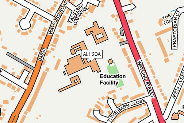
AL1 2QA is located in the Verulam electoral ward, within the local authority district of St Albans and the English Parliamentary constituency of St Albans. The Sub Integrated Care Board (ICB) Location is NHS Hertfordshire and West Essex ICB - 06N and the police force is Hertfordshire. This postcode has been in use since January 1980.


GetTheData
Source: OS OpenMap – Local (Ordnance Survey)
Source: OS VectorMap District (Ordnance Survey)
Licence: Open Government Licence (requires attribution)
| Easting | 514062 |
| Northing | 205732 |
| Latitude | 51.738697 |
| Longitude | -0.349510 |
GetTheData
Source: Open Postcode Geo
Licence: Open Government Licence
| Country | England |
| Postcode District | AL1 |
➜ See where AL1 is on a map ➜ Where is St Albans? | |
GetTheData
Source: Land Registry Price Paid Data
Licence: Open Government Licence
Elevation or altitude of AL1 2QA as distance above sea level:
| Metres | Feet | |
|---|---|---|
| Elevation | 100m | 328ft |
Elevation is measured from the approximate centre of the postcode, to the nearest point on an OS contour line from OS Terrain 50, which has contour spacing of ten vertical metres.
➜ How high above sea level am I? Find the elevation of your current position using your device's GPS.
GetTheData
Source: Open Postcode Elevation
Licence: Open Government Licence
| Ward | Verulam |
| Constituency | St Albans |
GetTheData
Source: ONS Postcode Database
Licence: Open Government Licence
| Midway (Watford Road) | St Stephens | 185m |
| King Harry Ph (Watford Road) | St Stephens | 248m |
| Midway (Watford Road) | St Stephens | 260m |
| King Harry Ph (Watford Road) | St Stephens | 285m |
| Vesta Avenue | St Julians | 287m |
| St Albans Abbey Station | 0.8km |
| Park Street Station | 1.6km |
| St Albans City Station | 2km |
GetTheData
Source: NaPTAN
Licence: Open Government Licence
GetTheData
Source: ONS Postcode Database
Licence: Open Government Licence


➜ Get more ratings from the Food Standards Agency
GetTheData
Source: Food Standards Agency
Licence: FSA terms & conditions
| Last Collection | |||
|---|---|---|---|
| Location | Mon-Fri | Sat | Distance |
| St Stephens P.o | 17:30 | 12:00 | 334m |
| Dellfield | 17:30 | 12:00 | 629m |
| The Brambles | 17:30 | 12:00 | 975m |
GetTheData
Source: Dracos
Licence: Creative Commons Attribution-ShareAlike
The below table lists the International Territorial Level (ITL) codes (formerly Nomenclature of Territorial Units for Statistics (NUTS) codes) and Local Administrative Units (LAU) codes for AL1 2QA:
| ITL 1 Code | Name |
|---|---|
| TLH | East |
| ITL 2 Code | Name |
| TLH2 | Bedfordshire and Hertfordshire |
| ITL 3 Code | Name |
| TLH23 | Hertfordshire CC |
| LAU 1 Code | Name |
| E07000240 | St Albans |
GetTheData
Source: ONS Postcode Directory
Licence: Open Government Licence
The below table lists the Census Output Area (OA), Lower Layer Super Output Area (LSOA), and Middle Layer Super Output Area (MSOA) for AL1 2QA:
| Code | Name | |
|---|---|---|
| OA | E00120578 | |
| LSOA | E01023744 | St Albans 014C |
| MSOA | E02004937 | St Albans 014 |
GetTheData
Source: ONS Postcode Directory
Licence: Open Government Licence
| AL1 2AN | Savoy Mews | 116m |
| AL1 2QB | Watling Street | 130m |
| AL1 2QD | Tithe Barn Close | 154m |
| AL1 2AD | Watford Road | 159m |
| AL1 2QY | Tithe Barn Close | 164m |
| AL1 2AL | Falstaff Gardens | 166m |
| AL1 2PX | Watling Street | 166m |
| AL1 2AH | Watford Road | 177m |
| AL1 2PY | Watling Street | 184m |
| AL1 2AE | Watford Road | 191m |
GetTheData
Source: Open Postcode Geo; Land Registry Price Paid Data
Licence: Open Government Licence