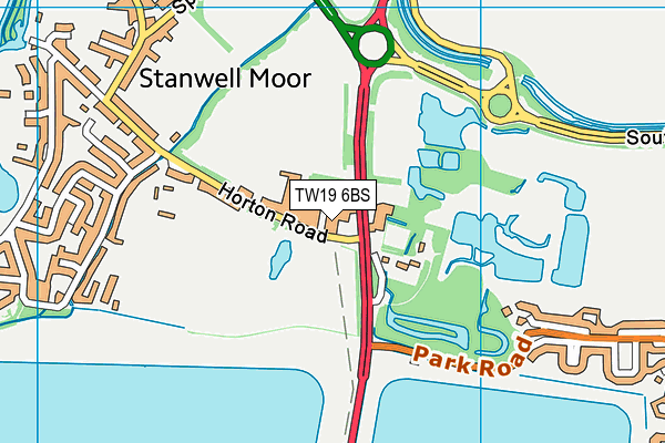
Green Corridor is located in Stanwell Moor Road, London and falls under the local authority of Hillingdon. This mixed-sex school has a capacity of 64 pupils, aged from sixteen up to twenty-five, and the type of establishment is special post 16 institution.
| Address | Green Corridor Main Road Nurseries Stanwell Moor Road London TW19 6BS |
| Website | http://www.greencorridor.org.uk |
| Headteacher | Mr Tim Whitelaw |
GetTheData
Source: Get Information About Schools
Licence: Open Government Licence
| Phase of Education | Not applicable |
| Type of Establishment | Special post 16 institution |
| Statutory Low Age | 16 |
| Statutory High Age | 25 |
| Boarders | No boarders |
| Official Sixth Form | Not applicable |
| Gender | Mixed |
| Religious Character | Does not apply |
| Diocese | Not applicable |
| Special Classes | Not applicable |
GetTheData
Source: Get Information About Schools
Licence: Open Government Licence
| School Capacity | 64 |
GetTheData
Source: Get Information About Schools
Licence: Open Government Licence
| Street Address | Main Road Nurseries |
| Locality | Stanwell Moor Road |
| Town | London |
| Postcode | TW19 6BS |
| ➜ More TW19 6BS open data | |
GetTheData
Source: Get Information About Schools
Licence: Open Government Licence

GetTheData
Source: OS VectorMap District (Ordnance Survey)
Licence: Open Government Licence (requires attribution)
| Ofsted Special Measures | Not applicable |
GetTheData
Source: Get Information About Schools
Licence: Open Government Licence
| Establishment Name | Green Corridor |
| Establishment Number | 7900 |
| Unique Reference Number | 146362 |
| Local Authority | Hillingdon |
| Local Authority Code | 312 |
| Previous Local Authority Code | 999 |
| Government Statistical Service Local Authority Code | E09000017 |
| Government Office Region | London |
| District | Spelthorne |
| District Code | E07000213 |
| Ward | Stanwell North |
| Parliamentary Constituency | Spelthorne |
| Urban/Rural Description | (England/Wales) Urban city and town |
| Middle Super Output Area | Spelthorne 001 |
| Lower Super Output Area | Spelthorne 001D |
GetTheData
Source: Get Information About Schools
Licence: Open Government Licence
| Establishment Status | Open |
| Last Changed Date | 14th November 2023 |
| Open Date | 17th May 2002 |
GetTheData
Source: Get Information About Schools
Licence: Open Government Licence
| Teenage Mothers | Not applicable |
| Special Educational Needs (SEN) Provision in Primary Care Unit | Not applicable |
| Pupil Referral Unit (PRU) Provides for Educational and Behavioural Difficulties (EBD) | Not applicable |
GetTheData
Source: Get Information About Schools
Licence: Open Government Licence
| Section 41 Approved | Approved |
GetTheData
Source: Get Information About Schools
Licence: Open Government Licence
| Trust flag | Not applicable |
| School Sponsor flag | Not applicable |
GetTheData
Source: Get Information About Schools
Licence: Open Government Licence
| Federation flag | Not applicable |
GetTheData
Source: Get Information About Schools
Licence: Open Government Licence
| UK Provider Reference Number | 10025289 |
GetTheData
Source: Get Information About Schools
Licence: Open Government Licence
| Easting | 504754 |
| Northing | 175584 |
| Latitude | 51.46954 |
| Longitude | -0.49325 |
GetTheData
Source: Get Information About Schools
Licence: Open Government Licence
| School | Phase of Education | Distance |
|---|---|---|
| Pippins School Raymond Close, Colnbrook, SL3 0PR | Primary | 1.7km |
| Town Farm Primary School & Nursery St Mary's Crescent, Stanwell, Staines, TW19 7HU | Primary | 2km |
| Harmondsworth Primary School School Road, Harmondsworth, West Drayton, UB7 0AU | Primary | 2.1km |
| Stanwell Fields CofE Primary School Clare Road, Stanwell, Staines-upon-Thames, TW19 7DB | Primary | 2.2km |
| Colnbrook Church of England Primary School High Street, Colnbrook, SL3 0JZ | Primary | 2.6km |
| Heathrow Primary School Harmondsworth Lane, Sipson, West Drayton, UB7 0JQ | Primary | 3.2km |
| St Martin's Church of England Primary School Rowan Road, West Drayton, UB7 7UF | Primary | 3.4km |
| Lady Nafisa School Inglenook, Sipson Lane, West Drayton, UB7 0JG | Not applicable | 3.4km |
| Laurel Lane Primary School Laurel Lane, West Drayton, UB7 7TX | Primary | 3.6km |
| Thomas Knyvett College Stanwell Road, Ashford, TW15 3DU | Secondary | 3.7km |
GetTheData
Source: Get Information About Schools
Licence: Open Government Licence